
Make a donation
Gear up for your next adventure:
As an Amazon Associate, this site earns from qualifying purchases at no extra cost to you.
Hebron topographic map
Click on the map to display elevation.
Make a donation
Gear up for your next adventure:
As an Amazon Associate, this site earns from qualifying purchases at no extra cost to you.
Hebron
Hebron sits at the north end of Newfound Lake, the fourth-largest lake in New Hampshire. The Cockermouth River, the primary feeder to the lake, enters the town from Groton to the west and passes the town center before entering the lake. Hebron lies fully within the Merrimack River watershed. The highest point in Hebron is a knob with an elevation of 2,240 feet (680 m) above sea level just south of the summit of Tenney Mountain, near the town's northernmost point.
Make a donation
Gear up for your next adventure:
As an Amazon Associate, this site earns from qualifying purchases at no extra cost to you.
About this map
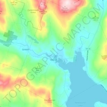
Name: Hebron topographic map, elevation, terrain.
Location: Hebron, Grafton County, New Hampshire, 03241, United States (43.65687 -71.84812 43.74075 -71.73392)
Average elevation: 1,073 ft
Minimum elevation: 564 ft
Maximum elevation: 2,316 ft
Grafton County trails, hiking, mountain biking, running and outdoor activities
Make a donation
Gear up for your next adventure:
As an Amazon Associate, this site earns from qualifying purchases at no extra cost to you.
Other topographic maps
Click on a map to view its topography, its elevation and its terrain.
Stinson Lake
United States > New Hampshire > Grafton County > Rumney > Stinson Lake
Average elevation: 1,509 ft
Make a donation
Gear up for your next adventure:
As an Amazon Associate, this site earns from qualifying purchases at no extra cost to you.
Make a donation
Gear up for your next adventure:
As an Amazon Associate, this site earns from qualifying purchases at no extra cost to you.
Middle Sugarloaf
United States > New Hampshire > Grafton County > Bethlehem
Average elevation: 1,942 ft
Make a donation
Gear up for your next adventure:
As an Amazon Associate, this site earns from qualifying purchases at no extra cost to you.
Make a donation
Gear up for your next adventure:
As an Amazon Associate, this site earns from qualifying purchases at no extra cost to you.
Campton Lower Village
United States > New Hampshire > Grafton County > Campton
Average elevation: 853 ft
Mount Pemigewasset
United States > New Hampshire > Grafton County > Lincoln
Average elevation: 1,995 ft
Make a donation
Gear up for your next adventure:
As an Amazon Associate, this site earns from qualifying purchases at no extra cost to you.
Campton Hollow
United States > New Hampshire > Grafton County > Campton > Campton Hollow
Average elevation: 823 ft
Make a donation
Gear up for your next adventure:
As an Amazon Associate, this site earns from qualifying purchases at no extra cost to you.
Corcoran Pond
United States > New Hampshire > Grafton County > Waterville Valley
Average elevation: 1,713 ft
Woodstock
United States > New Hampshire > Grafton County > Woodstock > Woodstock
Average elevation: 1,093 ft
Make a donation
Gear up for your next adventure:
As an Amazon Associate, this site earns from qualifying purchases at no extra cost to you.
Make a donation
Gear up for your next adventure:
As an Amazon Associate, this site earns from qualifying purchases at no extra cost to you.
Waterville Valley
United States > New Hampshire > Grafton County > Waterville Valley > Waterville Valley
Average elevation: 1,860 ft
Make a donation
Gear up for your next adventure:
As an Amazon Associate, this site earns from qualifying purchases at no extra cost to you.
Downing Mountain
United States > New Hampshire > Grafton County > Ellsworth
Average elevation: 1,460 ft