
Signa topographic map
Click on the map to display elevation.
About this map
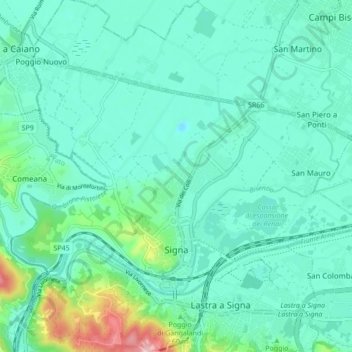
Name: Signa topographic map, elevation, terrain.
Location: Signa, Florence, Tuscany, 50058, Italy (43.77278 11.05618 43.81439 11.14193)
Average elevation: 157 ft
Minimum elevation: 33 ft
Maximum elevation: 719 ft
Other topographic maps
Click on a map to view its topography, its elevation and its terrain.
Castello di Mugnana
Italy > Tuscany > Florence > Greve in Chianti > Chiocchio > Mugnana
Average elevation: 1,063 ft