
Make a donation
Gear up for your next adventure:
As an Amazon Associate, this site earns from qualifying purchases at no extra cost to you.
Maplewood topographic map
Click on the map to display elevation.
Make a donation
Gear up for your next adventure:
As an Amazon Associate, this site earns from qualifying purchases at no extra cost to you.
About this map
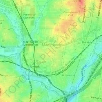
Name: Maplewood topographic map, elevation, terrain.
Average elevation: 492 ft
Minimum elevation: 413 ft
Maximum elevation: 594 ft
Make a donation
Gear up for your next adventure:
As an Amazon Associate, this site earns from qualifying purchases at no extra cost to you.
Other topographic maps
Click on a map to view its topography, its elevation and its terrain.
Make a donation
Gear up for your next adventure:
As an Amazon Associate, this site earns from qualifying purchases at no extra cost to you.
Make a donation
Gear up for your next adventure:
As an Amazon Associate, this site earns from qualifying purchases at no extra cost to you.
Clarkson Valley
United States > Missouri > Saint Louis County > Clarkson Valley
Average elevation: 640 ft
University City
United States > Missouri > Saint Louis County > University City > University City
Average elevation: 558 ft
Make a donation
Gear up for your next adventure:
As an Amazon Associate, this site earns from qualifying purchases at no extra cost to you.
Jennings
United States > Missouri > Saint Louis County > Jennings > Jennings
Average elevation: 518 ft
Town and Country
United States > Missouri > Saint Louis County > Town and Country > Town and Country
Average elevation: 584 ft