Geolocate

Lari topographic map

Click on the map to display elevation.

About this map

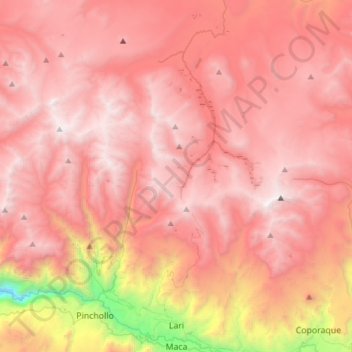
Name: Lari topographic map, elevation, terrain.

Location: Lari, Caylloma, Arequipa, Peru (-15.64561 -71.87674 -15.35192 -71.65034)

Average elevation: 15,148 ft

Minimum elevation: 8,615 ft

Maximum elevation: 18,307 ft

Other topographic maps

Click on a map to view its topography, its elevation and its terrain.

Llavepata

Peru > Arequipa

Average elevation: 14,895 ft

Potosi

Peru > Arequipa > Caylloma

Average elevation: 14,560 ft

Mirador Cruz del Condor

Peru > Arequipa > Cabanaconde > Media Luna

Average elevation: 11,657 ft

Nevado Mismi

Peru > Arequipa > Lari

Average elevation: 17,300 ft

Charco

Peru > Arequipa > Yanaquihua

Average elevation: 9,836 ft

Caylloma

Peru > Arequipa

Average elevation: 12,126 ft

Imata

Peru > Arequipa > Imata

Average elevation: 14,590 ft

Villa Sevilla

Peru > Arequipa > Jacobo Hunter > Villa Sevilla

Average elevation: 7,490 ft

Chalhuanca

Peru > Arequipa > Yanque

Average elevation: 14,318 ft

Catamarca

Peru > Arequipa > Tisco

Average elevation: 13,875 ft

Oroya

Peru > Arequipa > Achoma

Average elevation: 11,545 ft

Gear up for your next adventure:

🪶Fire Starter Kit - Reliable fire starter for survival and camping
🧤Tactile Hiking Gloves - Keep hands warm while operating GPS and smartphone screens
🧥Men's Rain Shells - Premium waterproof and breathable jackets for mountain weather
🖼️Topo Map Wall Art - Decorative topographic prints of famous peaks and regions
🗃️Trail First Aid Kit - Essential kit for outdoor injuries and emergencies

As an Amazon Associate, this site earns from qualifying purchases at no extra cost to you.