Geolocate

Sandvika topographic map

Click on the map to display elevation.

About this map

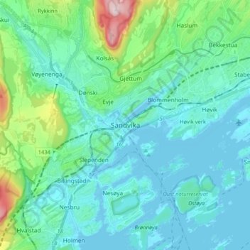
Name: Sandvika topographic map, elevation, terrain.

Location: Sandvika, Bærum, Viken, 1337, Norway (59.85212 10.48499 59.93212 10.56499)

Average elevation: 197 ft

Minimum elevation: -3 ft

Maximum elevation: 1,198 ft

Other topographic maps

Click on a map to view its topography, its elevation and its terrain.

Gol

Norway > Viken

Average elevation: 2,753 ft

Jevnaker

Norway > Viken

Average elevation: 1,142 ft

Nannestad

Norway > Viken

Average elevation: 1,086 ft

Lørenskog

Norway > Viken

Average elevation: 732 ft

Ribba

Norway > Viken

Average elevation: 16 ft

Lier

Norway > Viken

Average elevation: 928 ft

Ringerike

Norway > Viken

Average elevation: 1,453 ft

Kongsberg

Norway > Viken

Average elevation: 1,273 ft

Indre Østfold

Norway > Viken

Average elevation: 486 ft

Hvaler

Norway > Viken

Average elevation: 7 ft

Flå

Norway > Viken

Average elevation: 2,359 ft

Ullensaker

Norway > Viken

Average elevation: 594 ft

Gear up for your next adventure:

🥩Freeze-Dried Meals - Nutritious and lightweight food for remote expeditions
🔦Compact Flashlight - Reliable flashlight for emergencies
📷Action Camera - Capture your outdoor adventures in HD
🪶Wildlife Field Guides - Learn animal tracking and species ID
Solar GPS Watches - Advanced multisport watches with built-in topographic maps

As an Amazon Associate, this site earns from qualifying purchases at no extra cost to you.