
Make a donation
Gear up for your next adventure:
As an Amazon Associate, this site earns from qualifying purchases at no extra cost to you.
Glendale topographic map
Click on the map to display elevation.
Make a donation
Gear up for your next adventure:
As an Amazon Associate, this site earns from qualifying purchases at no extra cost to you.
About this map
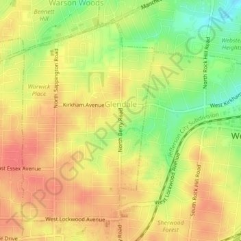
Name: Glendale topographic map, elevation, terrain.
Location: Glendale, Saint Louis County, Missouri, United States (38.58275 -90.39132 38.60530 -90.37226)
Average elevation: 587 ft
Minimum elevation: 472 ft
Maximum elevation: 659 ft
Saint Louis County trails, hiking, mountain biking, running and outdoor activities
Make a donation
Gear up for your next adventure:
As an Amazon Associate, this site earns from qualifying purchases at no extra cost to you.
Other topographic maps
Click on a map to view its topography, its elevation and its terrain.
Make a donation
Gear up for your next adventure:
As an Amazon Associate, this site earns from qualifying purchases at no extra cost to you.
Make a donation
Gear up for your next adventure:
As an Amazon Associate, this site earns from qualifying purchases at no extra cost to you.
Clarkson Valley
United States > Missouri > Saint Louis County > Clarkson Valley
Average elevation: 640 ft
University City
United States > Missouri > Saint Louis County > University City > University City
Average elevation: 558 ft
Make a donation
Gear up for your next adventure:
As an Amazon Associate, this site earns from qualifying purchases at no extra cost to you.
Jennings
United States > Missouri > Saint Louis County > Jennings > Jennings
Average elevation: 518 ft
Town and Country
United States > Missouri > Saint Louis County > Town and Country > Town and Country
Average elevation: 584 ft