
Make a donation
Gear up for your next adventure:
As an Amazon Associate, this site earns from qualifying purchases at no extra cost to you.
Wyre Forest topographic map
Click on the map to display elevation.
Make a donation
Gear up for your next adventure:
As an Amazon Associate, this site earns from qualifying purchases at no extra cost to you.
About this map
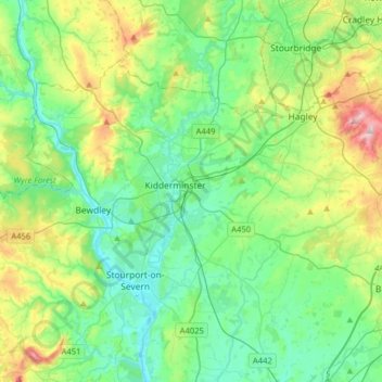
Name: Wyre Forest topographic map, elevation, terrain.
Location: Wyre Forest, Worcestershire, England, United Kingdom (52.31484 -2.43651 52.45530 -2.11922)
Average elevation: 302 ft
Minimum elevation: 52 ft
Maximum elevation: 1,020 ft
Make a donation
Gear up for your next adventure:
As an Amazon Associate, this site earns from qualifying purchases at no extra cost to you.
Other topographic maps
Click on a map to view its topography, its elevation and its terrain.
Worcestershire Beacon
United Kingdom > England > Worcestershire > Malvern Hills
Average elevation: 646 ft
Malvern
United Kingdom > England > Worcestershire > Malvern Hills
Malvern lies in the Lower Severn/Avon plain affording it a degree of shelter caused by virtue of its nestling in between the Cotswold hills to the east, the Welsh Hills and Mountains to the west, and Birmingham plateau to the north. Although as with all the British Isles it has a maritime climate, the local…
Average elevation: 312 ft
Make a donation
Gear up for your next adventure:
As an Amazon Associate, this site earns from qualifying purchases at no extra cost to you.
Make a donation
Gear up for your next adventure:
As an Amazon Associate, this site earns from qualifying purchases at no extra cost to you.
Make a donation
Gear up for your next adventure:
As an Amazon Associate, this site earns from qualifying purchases at no extra cost to you.
Make a donation
Gear up for your next adventure:
As an Amazon Associate, this site earns from qualifying purchases at no extra cost to you.
Marlbrook
United Kingdom > England > Worcestershire > Bromsgrove > Lydiate Ash
Average elevation: 581 ft
Make a donation
Gear up for your next adventure:
As an Amazon Associate, this site earns from qualifying purchases at no extra cost to you.
Whiteacres
United Kingdom > England > Worcestershire > Malvern Hills > Powick
Average elevation: 89 ft
Make a donation
Gear up for your next adventure:
As an Amazon Associate, this site earns from qualifying purchases at no extra cost to you.
Arrow Valley Country Park
United Kingdom > England > Worcestershire > Redditch
Average elevation: 285 ft
Make a donation
Gear up for your next adventure:
As an Amazon Associate, this site earns from qualifying purchases at no extra cost to you.
The Toposcope
United Kingdom > England > Worcestershire > Bromsgrove > Rubery
Average elevation: 741 ft
Make a donation
Gear up for your next adventure:
As an Amazon Associate, this site earns from qualifying purchases at no extra cost to you.
Table Hill
United Kingdom > England > Worcestershire > Malvern Hills
Table Hill is situated in the range of Malvern Hills that runs about 13 kilometres (8 mi) north-south along the Herefordshire-Worcestershire border. It lies between North Hill and Sugarloaf Hill and has an elevation of 373 metres (1,224 ft).
Average elevation: 617 ft
Elms Green
United Kingdom > England > Worcestershire > Malvern Hills > Abberley
Average elevation: 397 ft
Make a donation
Gear up for your next adventure:
As an Amazon Associate, this site earns from qualifying purchases at no extra cost to you.
Make a donation
Gear up for your next adventure:
As an Amazon Associate, this site earns from qualifying purchases at no extra cost to you.
Low Habberley
United Kingdom > England > Worcestershire > Wyre Forest > Ferndale
Average elevation: 279 ft
Make a donation
Gear up for your next adventure:
As an Amazon Associate, this site earns from qualifying purchases at no extra cost to you.
Stourport Historic Canal Basins
United Kingdom > England > Worcestershire > Wyre Forest > Stourport-on-Severn > Wilden
Average elevation: 108 ft
Badsey Lane Nature Reserve
United Kingdom > England > Worcestershire > Wychavon > Evesham
Average elevation: 121 ft
Morton Stanley Park
United Kingdom > England > Worcestershire > Redditch > Callow Hill
Average elevation: 423 ft
Make a donation
Gear up for your next adventure:
As an Amazon Associate, this site earns from qualifying purchases at no extra cost to you.
Atch Lench
United Kingdom > England > Worcestershire > Wychavon > Church Lench
Average elevation: 262 ft
Make a donation
Gear up for your next adventure:
As an Amazon Associate, this site earns from qualifying purchases at no extra cost to you.
Elcocks Brook
United Kingdom > England > Worcestershire > Redditch > Feckenham
Average elevation: 331 ft
Ronkswood Hill Meadows Local Nature Reserve
United Kingdom > England > Worcestershire > Worcester
Average elevation: 184 ft
Make a donation
Gear up for your next adventure:
As an Amazon Associate, this site earns from qualifying purchases at no extra cost to you.
Lickey Hills Country Park
United Kingdom > England > Worcestershire > Bromsgrove > Cofton Hackett CP
Average elevation: 686 ft
The Hill, Abberley
United Kingdom > England > Worcestershire > Malvern Hills > Abberley
Average elevation: 433 ft
Make a donation
Gear up for your next adventure:
As an Amazon Associate, this site earns from qualifying purchases at no extra cost to you.
Major's Green
United Kingdom > England > Worcestershire > Bromsgrove > Wythall CP
Average elevation: 479 ft
Bastonford
United Kingdom > England > Worcestershire > Malvern Hills > Powick
Average elevation: 121 ft
Make a donation
Gear up for your next adventure:
As an Amazon Associate, this site earns from qualifying purchases at no extra cost to you.
Beacon Wood
United Kingdom > England > Worcestershire > Bromsgrove > Lydiate Ash
Average elevation: 689 ft
Shatterford
United Kingdom > England > Worcestershire > Wyre Forest > Upper Arley
Average elevation: 407 ft
Tanner's Green
United Kingdom > England > Worcestershire > Bromsgrove > Wythall CP
Average elevation: 518 ft
Make a donation
Gear up for your next adventure:
As an Amazon Associate, this site earns from qualifying purchases at no extra cost to you.
Upper Broadheath
United Kingdom > England > Worcestershire > Malvern Hills > Crown East
Average elevation: 144 ft
Malvern
United Kingdom > England > Worcestershire > Malvern Hills
Malvern lies in the Lower Severn/Avon plain affording it a degree of shelter caused by virtue of its nestling in between the Cotswold hills to the east, the Welsh Hills and Mountains to the west, and Birmingham plateau to the north. Although as with all the British Isles it has a maritime climate, the local…
Average elevation: 312 ft
Corse Lawn
United Kingdom > England > Worcestershire > Malvern Hills > Eldersfield
Average elevation: 85 ft
Make a donation
Gear up for your next adventure:
As an Amazon Associate, this site earns from qualifying purchases at no extra cost to you.
Upper Welland
United Kingdom > England > Worcestershire
Upper Welland is a small settled area within the civil parish of Malvern Wells, in Worcestershire, England. Lying close to the county boundaries of Herefordshire.It was formed when the upper part of Welland parish joined the newly created Malvern Hills Urban District. Welland Parish once stretched to the ridge…
Average elevation: 377 ft
Make a donation
Gear up for your next adventure:
As an Amazon Associate, this site earns from qualifying purchases at no extra cost to you.
Make a donation
Gear up for your next adventure:
As an Amazon Associate, this site earns from qualifying purchases at no extra cost to you.
Make a donation
Gear up for your next adventure:
As an Amazon Associate, this site earns from qualifying purchases at no extra cost to you.
River Severn
United Kingdom > England > Worcestershire > Wyre Forest > Stourport-on-Severn
Average elevation: 148 ft
Make a donation
Gear up for your next adventure:
As an Amazon Associate, this site earns from qualifying purchases at no extra cost to you.
Beach Hay
United Kingdom > England > Worcestershire > Malvern Hills > Bayton
Average elevation: 499 ft
Blackwell
United Kingdom > England > Worcestershire > Bromsgrove > Blackwell
Average elevation: 531 ft
Lickey Hills Country Park
United Kingdom > England > Worcestershire > Birmingham > Rednal
Average elevation: 741 ft
Make a donation
Gear up for your next adventure:
As an Amazon Associate, this site earns from qualifying purchases at no extra cost to you.
Upper Wick
United Kingdom > England > Worcestershire > Malvern Hills District > Rushwick > Upper Wick
Average elevation: 98 ft
Foley Park
United Kingdom > England > Worcestershire > Wyre Forest District > Foley Park
Average elevation: 180 ft
Menithwood
United Kingdom > England > Worcestershire > Malvern Hills District > Menithwood
Average elevation: 400 ft
Make a donation
Gear up for your next adventure:
As an Amazon Associate, this site earns from qualifying purchases at no extra cost to you.
Welland Stone
United Kingdom > England > Worcestershire > Malvern Hills District
Average elevation: 95 ft