
Chatham topographic map
Click on the map to display elevation.
About this map
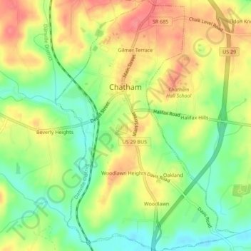
Name: Chatham topographic map, elevation, terrain.
Location: Chatham, Pittsylvania County, Virginia, United States (36.80344 -79.41000 36.83741 -79.37957)
Average elevation: 686 ft
Minimum elevation: 571 ft
Maximum elevation: 797 ft
Pittsylvania County trails, hiking, mountain biking, running and outdoor activities
Other topographic maps
Click on a map to view its topography, its elevation and its terrain.