
Camasca topographic map
Interactive map
Click on the map to display elevation.
About this map
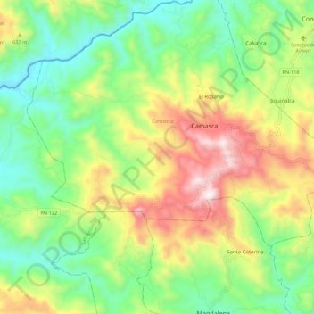
Name: Camasca topographic map, elevation, terrain.
Location: Camasca, Intibucá, Honduras (13.94210 -88.43813 14.02996 -88.32812)
Average elevation: 1,624 ft
Minimum elevation: 417 ft
Maximum elevation: 3,576 ft
Other topographic maps
Click on a map to view its topography, its elevation and its terrain.
Yamaranguila
Honduras > Intibucá > Yamaranguila
Yamaranguila, Intibucá, Honduras
Average elevation: 5,751 ft
Cerro El Pelón
Honduras > Intibucá > La Esperanza
Cerro El Pelón, La Esperanza, Intibucá, Honduras
Average elevation: 6,276 ft
La Esperanza
Honduras > Intibucá > La Esperanza
La Esperanza, Intibucá, Honduras
Average elevation: 5,033 ft
Jesús de Otoro
Honduras > Intibucá > Jesús de Otoro
Jesús de Otoro, Intibucá, Honduras
Average elevation: 2,431 ft
Río Guarajambala
Honduras > Intibucá > La Esperanza
Río Guarajambala, La Esperanza, Intibucá, Honduras
Average elevation: 1,604 ft