
Make a donation
Gear up for your next adventure:
As an Amazon Associate, this site earns from qualifying purchases at no extra cost to you.
Intibucá topographic map
Click on the map to display elevation.
Make a donation
Gear up for your next adventure:
As an Amazon Associate, this site earns from qualifying purchases at no extra cost to you.
About this map
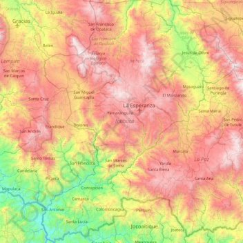
Name: Intibucá topographic map, elevation, terrain.
Location: Intibucá, Honduras (13.84863 -88.51109 14.66283 -87.84765)
Average elevation: 3,793 ft
Minimum elevation: 190 ft
Maximum elevation: 7,772 ft
Make a donation
Gear up for your next adventure:
As an Amazon Associate, this site earns from qualifying purchases at no extra cost to you.
Other topographic maps
Click on a map to view its topography, its elevation and its terrain.
Tegucigalpa
Honduras > Francisco Morazán > Tegucigalpa > Tegucigalpa
Al igual que gran parte del centro de Honduras, la ciudad tiene un clima tropical, aunque templado por la altitud, lo que significa menos húmedo que los valles más bajos y las regiones costeras. Cuenta con dos temporadas, la temporada seca y fría que comienza en noviembre y finaliza en marzo y la temporada…
Average elevation: 4,199 ft
San Pedro Sula
La ciudad consta de una topografía plana con una ligera inclinación hacia el oriente, al sur con el río Chamelecón y al oeste con la montaña del Merendón. "Por sus características topográficas San Pedro Sula puede dividirse en dos zonas: (1) La Zona de Reserva de la Cordillera del Merendón, que ocupa…
Average elevation: 951 ft
Make a donation
Gear up for your next adventure:
As an Amazon Associate, this site earns from qualifying purchases at no extra cost to you.
Parque Nacional La Tigra
La Tigra es un bosque nublado con una superficie de 328 kilómetros cuadrados (127 millas cuadradas). Tiene una altitud de entre 1800 y 2185 metros. Está ubicado a 25 km (16 millas) de []], y con a mayor extensión territorial...
Average elevation: 4,104 ft
Make a donation
Gear up for your next adventure:
As an Amazon Associate, this site earns from qualifying purchases at no extra cost to you.
Make a donation
Gear up for your next adventure:
As an Amazon Associate, this site earns from qualifying purchases at no extra cost to you.
Make a donation
Gear up for your next adventure:
As an Amazon Associate, this site earns from qualifying purchases at no extra cost to you.
Make a donation
Gear up for your next adventure:
As an Amazon Associate, this site earns from qualifying purchases at no extra cost to you.
Make a donation
Gear up for your next adventure:
As an Amazon Associate, this site earns from qualifying purchases at no extra cost to you.
Make a donation
Gear up for your next adventure:
As an Amazon Associate, this site earns from qualifying purchases at no extra cost to you.
Make a donation
Gear up for your next adventure:
As an Amazon Associate, this site earns from qualifying purchases at no extra cost to you.
Parque El Trapiche
Honduras > Francisco Morazán > Distrito Central > Tegucigalpa
Average elevation: 3,415 ft
Make a donation
Gear up for your next adventure:
As an Amazon Associate, this site earns from qualifying purchases at no extra cost to you.
Make a donation
Gear up for your next adventure:
As an Amazon Associate, this site earns from qualifying purchases at no extra cost to you.
Make a donation
Gear up for your next adventure:
As an Amazon Associate, this site earns from qualifying purchases at no extra cost to you.
Make a donation
Gear up for your next adventure:
As an Amazon Associate, this site earns from qualifying purchases at no extra cost to you.
Make a donation
Gear up for your next adventure:
As an Amazon Associate, this site earns from qualifying purchases at no extra cost to you.
El Zarzal
Honduras > Francisco Morazán > San Antonio de Oriente > San Antonio de Oriente
Average elevation: 2,894 ft
Make a donation
Gear up for your next adventure:
As an Amazon Associate, this site earns from qualifying purchases at no extra cost to you.
Make a donation
Gear up for your next adventure:
As an Amazon Associate, this site earns from qualifying purchases at no extra cost to you.
Make a donation
Gear up for your next adventure:
As an Amazon Associate, this site earns from qualifying purchases at no extra cost to you.
Make a donation
Gear up for your next adventure:
As an Amazon Associate, this site earns from qualifying purchases at no extra cost to you.
Rio Grande o Choluteca
Honduras > Francisco Morazán > Distrito Central > Tegucigalpa > Comayagüela
Average elevation: 3,173 ft
Make a donation
Gear up for your next adventure:
As an Amazon Associate, this site earns from qualifying purchases at no extra cost to you.
Make a donation
Gear up for your next adventure:
As an Amazon Associate, this site earns from qualifying purchases at no extra cost to you.
Make a donation
Gear up for your next adventure:
As an Amazon Associate, this site earns from qualifying purchases at no extra cost to you.
Make a donation
Gear up for your next adventure:
As an Amazon Associate, this site earns from qualifying purchases at no extra cost to you.
La Chácara
Honduras > Comayagua > Aldea de Montecitos > Caserio La Chacara
Average elevation: 2,762 ft
Make a donation
Gear up for your next adventure:
As an Amazon Associate, this site earns from qualifying purchases at no extra cost to you.
Make a donation
Gear up for your next adventure:
As an Amazon Associate, this site earns from qualifying purchases at no extra cost to you.
Make a donation
Gear up for your next adventure:
As an Amazon Associate, this site earns from qualifying purchases at no extra cost to you.
Río Chamelecón (Cause Original)
Honduras > Cortés > Puerto Cortés > Las Cruces
Average elevation: 20 ft
Make a donation
Gear up for your next adventure:
As an Amazon Associate, this site earns from qualifying purchases at no extra cost to you.