
Tiaparo topographic map
Click on the map to display elevation.
About this map
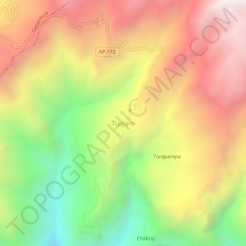
Name: Tiaparo topographic map, elevation, terrain.
Location: Tiaparo, Pocohuanca, Aymaraes, Apurímac, Perú (-14.19648 -73.11618 -14.15648 -73.07618)
Average elevation: 11,962 ft
Minimum elevation: 9,009 ft
Maximum elevation: 14,665 ft
Other topographic maps
Click on a map to view its topography, its elevation and its terrain.
Pacobamba
El Distrito de Pacobamba se encuentra ubicado en el extreño oriental de la Provincia de Andahuaylas de la Región Apurimac con una extensión de 245,90 km cuadrados con variación de relieve de acuerdo a la altitud desde 1.100 m s. n. m. hasta 4,800 m s. n. m. Tiene una población calculada de 8,200…
Average elevation: 8,839 ft
San Jerónimo
El distrito fue creado el 21 de junio de 1825, por el libertador José de San Martín. Tiene una población aproximada de 15.750 habitantes, se encuentra a solo 2 kilómetros de la capital de la provincia, Andahuaylas. Se encuentra a una altitud de 2965 metros sobre el nivel del mar. La fecha de su fundación…
Average elevation: 11,929 ft
Pichirhua
Climas: Por su situación geográfica que abarca diferentes zonas altitudinales, el clima no es homogéneo , sino que varía de cálido a frígido. Presenta dos estaciones bien marcadas: de mayo a octubre con ausencia de lluvias; de diciembre a marzo, con lluvias intensas originando derrumbes y huaycos. En la…
Average elevation: 11,742 ft
San Jerónimo
El distrito fue creado el 21 de junio de 1825, por el libertador José de San Martín. Tiene una población aproximada de 15.750 habitantes, se encuentra a solo 2 kilómetros de la capital de la provincia, Andahuaylas. Se encuentra a una altitud de 2965 metros sobre el nivel del mar. La fecha de su fundación…
Average elevation: 12,710 ft