
Mara topographic map
Click on the map to display elevation.
About this map
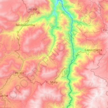
Name: Mara topographic map, elevation, terrain.
Location: Mara, Cotabambas, Apurímac, Perú (-14.14903 -72.20335 -13.88576 -72.05120)
Average elevation: 12,444 ft
Minimum elevation: 8,054 ft
Maximum elevation: 15,302 ft
Other topographic maps
Click on a map to view its topography, its elevation and its terrain.
Abancay
Abancay está ubicado en el sur de los andes peruanos, entre las cordilleras oriental y occidental, a una altitud de 2,377 m s. n. m. a orillas del río Mariño, afluente del río Pachachaca. Debido a sus montañas secas y su clima cálido todo el año es conocido como "El valle de la eterna primavera".…
Average elevation: 11,155 ft
Uripa
Perú > Apurímac > Anco-Huallo
Uripa es una localidad de Perú. Es capital del distrito de Anco_Huallo en la provincia de Chincheros, departamento de Apurímac. Se encuentra a aproximadamente a 110 kilómetros de la ciudad de Andahuaylas. Está a una altitud de 3105 m.s.n.m y tiene una población de 5038 habitantes en 2017.
Average elevation: 11,752 ft
Cachora
Perú > Apurímac > San Pedro de Cachora
Cachora es una localidad peruana ubicada en la región Apurímac, provincia de Abancay, distrito de San Pedro de Cachora, Perú. Se encuentra a una altitud de 2902 m s. n. m. Tenía una población de 703 habitantes en 1993.
Average elevation: 10,390 ft
Uripa
Perú > Apurímac > Anco-Huallo
Uripa es una localidad de Perú. Es capital del distrito de Anco Huallo en la provincia de Chincheros, departamento de Apurímac. Se encuentra a aproximadamente a 110 kilómetros de la ciudad de Andahuaylas. Está a una altitud de 3105 m.s.n.m y tiene una población de 5038 habitantes en 2017.
Average elevation: 11,752 ft