
Dubai Hills topographic map
Interactive map
Click on the map to display elevation.
About this map
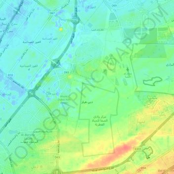
Name: Dubai Hills topographic map, elevation, terrain.
Location: Dubai Hills, Dubai, United Arab Emirates (25.05592 55.23302 25.15540 55.29577)
Average elevation: 46 ft
Minimum elevation: -66 ft
Maximum elevation: 148 ft
Other topographic maps
Click on a map to view its topography, its elevation and its terrain.
The World
United Arab Emirates > Dubai > Dubai
The World, Dubai, United Arab Emirates
Average elevation: 0 ft
Saih Al Salam
Saih Al Salam, Dubai, United Arab Emirates
Average elevation: 308 ft
Al Hamriya
United Arab Emirates > Dubai > Dubai
Al Hamriya, Dubai, United Arab Emirates
Average elevation: 20 ft
Dubai Creek
United Arab Emirates > Dubai > Deira
Dubai Creek, Deira, Dubai, United Arab Emirates
Average elevation: 10 ft
Palm Jumeirah
United Arab Emirates > Dubai > Dubai
Palm Jumeirah, Dubai, United Arab Emirates
Average elevation: 0 ft
Al Rigga
United Arab Emirates > Dubai > Deira
Al Rigga, Deira, Dubai, United Arab Emirates, park deira duabi
Average elevation: 20 ft
Al Jaddaf
United Arab Emirates > Dubai > Dubai
Al Jaddaf, Dubai, United Arab Emirates
Average elevation: -20 ft
NIkki Beach
United Arab Emirates > Dubai > Dubai
NIkki Beach, Dubai, United Arab Emirates
Average elevation: 0 ft
Al Karama
United Arab Emirates > Dubai > Dubai
Al Karama, Dubai, United Arab Emirates
Average elevation: 16 ft
Jumeirah
United Arab Emirates > Dubai > Dubai
Jumeirah, Dubai, United Arab Emirates
Average elevation: 7 ft
Jabal Ali
Jabal Ali, Jebel Ali Village, Dubai, 14225, United Arab Emirates
Average elevation: 46 ft
Nad Al Sheba
Nad Al Sheba, Dubai, United Arab Emirates
Average elevation: 43 ft
Al Khawaneej
Al Khawaneej, Dubai, United Arab Emirates
Average elevation: 164 ft
Dubai Media City Lake
Dubai Media City Lake, Dubai Media City, Dubai Knowledge Park, Dubai, United Arab Emirates
Average elevation: 3 ft
Dubai Creek
United Arab Emirates > Dubai > Dubai
Dubai Creek, Dubai, 39205, United Arab Emirates
Average elevation: 10 ft
Jabal Hajarayn
Jabal Hajarayn, Dubai, United Arab Emirates
Average elevation: 3,120 ft
Navajo Lake
Navajo Lake, Dubai, United Arab Emirates
Average elevation: 0 ft
El Paso, Texas
United Arab Emirates > Dubai > Dubai
El Paso, Texas, Dubai, United Arab Emirates
Average elevation: 0 ft
Jbr
Jbr, Al Mamsha Street, The Walk at Jumeirah Beach Residence, Dubai Marina, Dubai, 120253, United Arab Emirates
Average elevation: 3 ft
Karama Park
United Arab Emirates > Dubai > Dubai
Karama Park, Al Karamah, Dubai, United Arab Emirates
Average elevation: 13 ft
Deira
United Arab Emirates > Dubai > Deira
Deira, Dubai, 103711, United Arab Emirates
Average elevation: 7 ft
Dubai Silicon Oasis
United Arab Emirates > Dubai > Dubai
Dubai Silicon Oasis, Semmer Villas B & D, Dubai, United Arab Emirates
Average elevation: 95 ft
Business Bay
Business Bay, Dubai, United Arab Emirates
Average elevation: 10 ft
Emaar Business Park
Emaar Business Park, Barsha Heights, Dubai Media City 2, Dubai, United Arab Emirates
Average elevation: 3 ft
United Arab Emirates
United Arab Emirates, Dubai, United Arab Emirates
Average elevation: 0 ft
Al Jadaf
United Arab Emirates > Dubai > Al Jadaf
Al Jadaf, Dubai, 128940, United Arab Emirates
Average elevation: -30 ft
Gavutu
United Arab Emirates > Dubai > Dubai
Gavutu, Crescent Road East, Palm Jumeirah, Dubai, United Arab Emirates
Average elevation: 0 ft
Deira Island
United Arab Emirates > Dubai > Dubai
Deira Island, Dubai, United Arab Emirates
Average elevation: 3 ft
Pearl Jumeirah
United Arab Emirates > Dubai > Dubai
Pearl Jumeirah, Dubai, United Arab Emirates
Average elevation: 3 ft