
Mew Lake topographic map
Click on the map to display elevation.
About this map
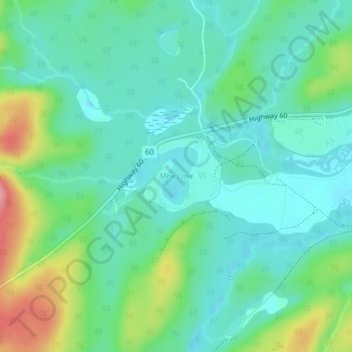
Name: Mew Lake topographic map, elevation, terrain.
Average elevation: 1,375 ft
Minimum elevation: 1,266 ft
Maximum elevation: 1,660 ft
Other topographic maps
Click on a map to view its topography, its elevation and its terrain.
Smoke Lake
Canada > Ontario > Nipissing District > Unorganized South Nipissing
Average elevation: 1,440 ft
Arrow Lake
Canada > Ontario > Nipissing District > Unorganized South Nipissing
Average elevation: 1,358 ft
Madawaska Highlands
Canada > Ontario > Nipissing District > Unorganized South Nipissing
Average elevation: 1,217 ft
Rose Lake
Canada > Ontario > Nipissing District > Unorganized South Nipissing
Average elevation: 1,506 ft
Carcajou Lake
Canada > Ontario > Nipissing District > Unorganized South Nipissing
Average elevation: 955 ft
William Lake
Canada > Ontario > Nipissing District > Unorganized South Nipissing
Average elevation: 1,381 ft
Mizzy Lake
Canada > Ontario > Nipissing District > Unorganized South Nipissing
Average elevation: 1,506 ft
Gilmour Island
Canada > Ontario > Nipissing District > Unorganized South Nipissing
Average elevation: 1,112 ft
Coldspring Lake
Canada > Ontario > Nipissing District > Unorganized South Nipissing
Average elevation: 1,444 ft
Beau Lake
Canada > Ontario > Nipissing District > Unorganized South Nipissing
Average elevation: 1,365 ft
Windermere Lake
Canada > Ontario > Nipissing District > Unorganized South Nipissing
Average elevation: 1,165 ft
Thistle Lake
Canada > Ontario > Nipissing District > Unorganized South Nipissing
Average elevation: 1,506 ft