Geolocate

Enterprise topographic map

Click on the map to display elevation.

About this map

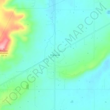
Name: Enterprise topographic map, elevation, terrain.

Location: Enterprise, Haskell County, Oklahoma, United States (35.20982 -95.39997 35.24982 -95.35997)

Average elevation: 702 ft

Minimum elevation: 594 ft

Maximum elevation: 1,109 ft

Haskell County trails, hiking, mountain biking, running and outdoor activities

Other topographic maps

Click on a map to view its topography, its elevation and its terrain.

Tamaha

United States > Oklahoma > Haskell County

Average elevation: 482 ft

Whitefield

United States > Oklahoma > Haskell County

Average elevation: 531 ft

McCurtain

United States > Oklahoma > Haskell County

Average elevation: 587 ft

Keota

United States > Oklahoma > Haskell County

Average elevation: 489 ft

Kinta

United States > Oklahoma > Haskell County

Average elevation: 564 ft

Stigler

United States > Oklahoma > Haskell County

Average elevation: 577 ft

Gear up for your next adventure:

🦟Ultrasonic Repellers - Create a bug-free zone at your camp or rest stop
📱Solar Portable Charger - Solar power bank for charging devices off‑grid
🧦Merino Wool Socks - Moisture-wicking, blister-preventing socks for long treks
❄️Traction Cleats - Prevent slips on icy trails during winter hikes
🪄Magnetic Compass - Accurate compass for navigation

As an Amazon Associate, this site earns from qualifying purchases at no extra cost to you.