
Make a donation
Gear up for your next adventure:
As an Amazon Associate, this site earns from qualifying purchases at no extra cost to you.
Bongo District topographic map
Click on the map to display elevation.
Make a donation
Gear up for your next adventure:
As an Amazon Associate, this site earns from qualifying purchases at no extra cost to you.
Bongo District
The area is generally flat with occasional outcrops of rocks at an elevation of 200 m. The landscape has little vegetation. The landscape borders on the Sudan Savannah Zone although technically in the Guinea Savannah Zone. The area is in danger of desertification. There is an average of 70 rain days a year, with an annual rainfall of 600–1,400 mm.
Make a donation
Gear up for your next adventure:
As an Amazon Associate, this site earns from qualifying purchases at no extra cost to you.
About this map
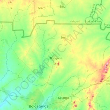
Name: Bongo District topographic map, elevation, terrain.
Location: Bongo District, Upper East Region, Ghana (10.82762 -0.93393 11.00649 -0.64491)
Average elevation: 728 ft
Minimum elevation: 522 ft
Maximum elevation: 1,207 ft
Make a donation
Gear up for your next adventure:
As an Amazon Associate, this site earns from qualifying purchases at no extra cost to you.
Other topographic maps
Click on a map to view its topography, its elevation and its terrain.
Make a donation
Gear up for your next adventure:
As an Amazon Associate, this site earns from qualifying purchases at no extra cost to you.
Make a donation
Gear up for your next adventure:
As an Amazon Associate, this site earns from qualifying purchases at no extra cost to you.
Make a donation
Gear up for your next adventure:
As an Amazon Associate, this site earns from qualifying purchases at no extra cost to you.
Make a donation
Gear up for your next adventure:
As an Amazon Associate, this site earns from qualifying purchases at no extra cost to you.
Make a donation
Gear up for your next adventure:
As an Amazon Associate, this site earns from qualifying purchases at no extra cost to you.
Sefwi Bekwai
Ghana > Western North Region > Bibiani Anhwiaso Bekwai Municipal District
Average elevation: 581 ft
Make a donation
Gear up for your next adventure:
As an Amazon Associate, this site earns from qualifying purchases at no extra cost to you.
Sekondi-Takoradi
Ghana > Western Region > Sekondi Takoradi Metropolitan District > Sekondi-Takoradi
Average elevation: 62 ft
Make a donation
Gear up for your next adventure:
As an Amazon Associate, this site earns from qualifying purchases at no extra cost to you.
Make a donation
Gear up for your next adventure:
As an Amazon Associate, this site earns from qualifying purchases at no extra cost to you.
Abeka
Ghana > Greater Accra Region > Okaikwei North Municipal District > Accra
Average elevation: 118 ft
Make a donation
Gear up for your next adventure:
As an Amazon Associate, this site earns from qualifying purchases at no extra cost to you.
Border Northern Region - Savannah Region
Ghana > Northern Region > Kpandai District > Kalande
Average elevation: 374 ft