Geolocate

Metauro topographic map

Click on the map to display elevation.

Metauro

The name of the river in Latin is Metaurus or Mataurus. In Ancient Greek, the name of the river is Métauros, Μέταυρος which stems simply from the union of the two torrents: Meta, running from the Apennine pass Bocca Trabaria, at an elevation of 1,044 metres (3,425 ft), and Auro, flowing from Monte Maggiore, at an elevation of 1,384 metres (4,541 ft).

Wikipedia (CC-BY-SA 3.0)

About this map

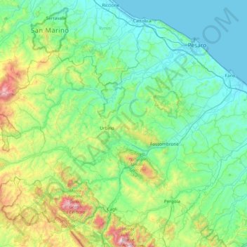
Name: Metauro topographic map, elevation, terrain.

Location: Metauro, Marche, Italy (43.64251 12.29656 43.82887 13.05533)

Average elevation: 1,027 ft

Minimum elevation: -3 ft

Maximum elevation: 5,449 ft

Other topographic maps

Click on a map to view its topography, its elevation and its terrain.

Monte Priora

Italy > Marche > Fermo > Montefortino

Average elevation: 5,932 ft

Vecciola di Sopra

Italy > Marche > Macerata > Sarnano

Average elevation: 1,736 ft

San Martino

Italy > Marche > Macerata > Sant'Angelo in Pontano

Average elevation: 899 ft

Anselmi

Italy > Marche > Macerata > Monte San Martino

Average elevation: 1,329 ft

Petrella

Italy > Marche > Ascoli Piceno > Ripatransone

Average elevation: 791 ft

Magazzini

Italy > Marche > Ascoli Piceno > Ripatransone

Average elevation: 482 ft

Ponte Tesino

Italy > Marche > Ascoli Piceno > Cossignano

Average elevation: 820 ft

Coriconi

Italy > Marche > Fermo > Amandola

Average elevation: 1,657 ft

Conca degli Ulivi

Italy > Marche > Ascoli Piceno > Acquaviva Picena

Average elevation: 479 ft

San Martino

Italy > Marche > Ascoli Piceno > Castignano

Average elevation: 1,276 ft

Lucrezia

Italy > Marche > Pesaro e Urbino

Average elevation: 223 ft

Aurora

Italy > Marche > Macerata > Civitanova Marche

Average elevation: 79 ft

San Lazzaro

Italy > Marche > Pesaro e Urbino > Fossombrone

Average elevation: 1,001 ft

Monterosso

Italy > Marche > Sassoferrato > Monterosso

Average elevation: 1,444 ft

Piediripa

Italy > Marche > Macerata > Piediripa

Average elevation: 413 ft

Gabriella

Italy > Marche > Ancona > Senigallia

Average elevation: 138 ft

Monte Sibilla

Italy > Marche > Ascoli Piceno > Montemonaco

Average elevation: 5,384 ft

Vestignano

Italy > Marche > Macerata > Caldarola

Average elevation: 2,067 ft

Gear up for your next adventure:

📚USA Hiking Guide Books - Top trail guides and map books
🥇GPS Hiking Watch - Multi‑sport GPS watch with navigation and trail tracking
🌡️Handheld Weather Meters - Measure wind, temp, and pressure for safe mountain travel
🔭Compact Binoculars - HD vision for scouting terrain and identifying distant landmarks
🧤Tactile Hiking Gloves - Keep hands warm while operating GPS and smartphone screens

As an Amazon Associate, this site earns from qualifying purchases at no extra cost to you.