
Make a donation
Gear up for your next adventure:
As an Amazon Associate, this site earns from qualifying purchases at no extra cost to you.
Wuppertal topographic map
Click on the map to display elevation.
Make a donation
Gear up for your next adventure:
As an Amazon Associate, this site earns from qualifying purchases at no extra cost to you.
Wuppertal
Uniquely for Germany, it is a "linear city", owing to the steep hillsides along the river Wupper. Its highest hill is the Lichtscheid, which is 351 m (1,152 ft) above sea level. The dominant urban centres Elberfeld (historic commercial centre) and Barmen (more industrial) have formed a continuous urbanized area since 1850. During the succeeding decades, "Wupper-Town" became the dominant industrial agglomeration of northwestern Germany. During the 20th century, this conurbation had been surpassed by Cologne, Düsseldorf and the Ruhr area, all with a more favourable topography.
Make a donation
Gear up for your next adventure:
As an Amazon Associate, this site earns from qualifying purchases at no extra cost to you.
About this map
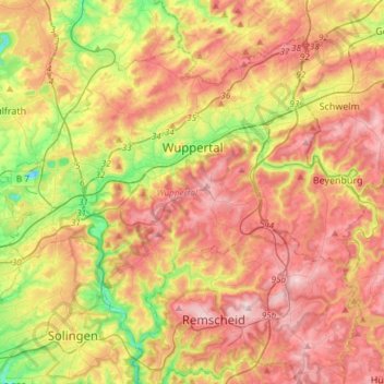
Name: Wuppertal topographic map, elevation, terrain.
Location: Wuppertal, North Rhine-Westphalia, Germany (51.16572 7.01407 51.31810 7.31343)
Average elevation: 794 ft
Minimum elevation: 285 ft
Maximum elevation: 1,247 ft
Make a donation
Gear up for your next adventure:
As an Amazon Associate, this site earns from qualifying purchases at no extra cost to you.
Other topographic maps
Click on a map to view its topography, its elevation and its terrain.
Wuppertal
Germany > North Rhine-Westphalia > Wuppertal
Uniquely for Germany, it is a "linear city", owing to the steep hillsides along the river Wupper. Its highest hill is the Lichtscheid, which is 351 metres above sea level. The dominant urban centres Elberfeld (historic commercial centre) and Barmen (more industrial) have formed a continuous urbanized area…
Average elevation: 686 ft
Make a donation
Gear up for your next adventure:
As an Amazon Associate, this site earns from qualifying purchases at no extra cost to you.
Rotthausen
Germany > North Rhine-Westphalia > Märkischer Kreis > Schalksmühle
Average elevation: 1,125 ft
Make a donation
Gear up for your next adventure:
As an Amazon Associate, this site earns from qualifying purchases at no extra cost to you.
Make a donation
Gear up for your next adventure:
As an Amazon Associate, this site earns from qualifying purchases at no extra cost to you.
Kleingladbach
Germany > North Rhine-Westphalia > Kreis Heinsberg > Hückelhoven
Average elevation: 276 ft
Bochum
Germany > North Rhine-Westphalia > Bochum
The city lies on the low rolling hills of Bochum land ridge (Bochumer Landrücken), part of the Ruhrhöhen (highest elevations) between the Ruhr and Emscher rivers at the border of the southern and northern Ruhr coal region. The highest point of the city is at Kemnader Straße (Kemnader Street) in Stiepel at…
Average elevation: 351 ft
Wahnenbusch
Germany > North Rhine-Westphalia > Kreis Heinsberg > Erkelenz > Tenholt
Average elevation: 308 ft
Make a donation
Gear up for your next adventure:
As an Amazon Associate, this site earns from qualifying purchases at no extra cost to you.
Reineberg
Germany > North Rhine-Westphalia > Kreis Minden-Lübbecke > Lübbecke
The Reineberg is a hill on the Wiehen ridge, south of the town of Lübbecke. With a height of 275.9 m above sea level it is, from a topographical point of view, not a particularly impressive eminence in this part of the Wiehen Hills, because, in the immediate vicinity are considerably higher summits, such as…
Average elevation: 594 ft
Gelstern
Germany > North Rhine-Westphalia > Märkischer Kreis > Schalksmühle > Heedfeld
Average elevation: 1,263 ft
Make a donation
Gear up for your next adventure:
As an Amazon Associate, this site earns from qualifying purchases at no extra cost to you.
Ruhrquelle
Germany > North Rhine-Westphalia > Hochsauerlandkreis > Winterberg > Grönebach
Average elevation: 2,116 ft
Wald
Germany > North Rhine-Westphalia > Kreis Euskirchen > Bad Münstereifel
Average elevation: 1,253 ft
Obernberg
Germany > North Rhine-Westphalia > Kreis Siegen-Wittgenstein > Bad Laasphe
Average elevation: 1,601 ft
Make a donation
Gear up for your next adventure:
As an Amazon Associate, this site earns from qualifying purchases at no extra cost to you.
Lenneplätze
Germany > North Rhine-Westphalia > Hochsauerlandkreis > Winterberg > Neuastenberg
Average elevation: 2,293 ft
Holtwick
Germany > North Rhine-Westphalia > Kreis Recklinghausen > Haltern am See
Average elevation: 292 ft
Make a donation
Gear up for your next adventure:
As an Amazon Associate, this site earns from qualifying purchases at no extra cost to you.
Schevenhütte
Germany > North Rhine-Westphalia > Städteregion Aachen > Stolberg
Average elevation: 801 ft
Remlingrade
Germany > North Rhine-Westphalia > Oberbergischer Kreis > Radevormwald
Average elevation: 1,004 ft
Watern
Germany > North Rhine-Westphalia > Kreis Heinsberg > Wegberg > Klinkum
Average elevation: 253 ft
Gellinghausen
Germany > North Rhine-Westphalia > Hochsauerlandkreis > Schmallenberg > Westernbödefeld
Average elevation: 1,854 ft
Make a donation
Gear up for your next adventure:
As an Amazon Associate, this site earns from qualifying purchases at no extra cost to you.
Sythen
Germany > North Rhine-Westphalia > Kreis Recklinghausen > Haltern am See
Average elevation: 177 ft
Make a donation
Gear up for your next adventure:
As an Amazon Associate, this site earns from qualifying purchases at no extra cost to you.
Bolzenbach
Germany > North Rhine-Westphalia > Oberbergischer Kreis > Lindlar
Average elevation: 869 ft
Leuth
Germany > North Rhine-Westphalia > Kreis Viersen > Region Kempen-Viersen
Average elevation: 141 ft
Lützinghausen
Germany > North Rhine-Westphalia > Oberbergischer Kreis > Gummersbach
Average elevation: 1,017 ft
Make a donation
Gear up for your next adventure:
As an Amazon Associate, this site earns from qualifying purchases at no extra cost to you.
Ketzbergerhöhe
Germany > North Rhine-Westphalia > Rheinisch-Bergischer Kreis > Wermelskirchen > Dabringhausen
Average elevation: 712 ft
Weißer Stein City
Germany > North Rhine-Westphalia > Kreis Euskirchen > Udenbreth
Average elevation: 2,113 ft
Make a donation
Gear up for your next adventure:
As an Amazon Associate, this site earns from qualifying purchases at no extra cost to you.
Altfinnentrop
Germany > North Rhine-Westphalia > Kreis Olpe > Finnentrop > Heggen
Average elevation: 1,037 ft
Wolkenberg
Germany > North Rhine-Westphalia > Hochsauerlandkreis > Olsberg
Average elevation: 1,739 ft
Make a donation
Gear up for your next adventure:
As an Amazon Associate, this site earns from qualifying purchases at no extra cost to you.
Make a donation
Gear up for your next adventure:
As an Amazon Associate, this site earns from qualifying purchases at no extra cost to you.
Hüthum
Germany > North Rhine-Westphalia > Kreis Kleve > Emmerich on the Rhine
Average elevation: 56 ft
Neuastenberg
Germany > North Rhine-Westphalia > Hochsauerlandkreis > Winterberg
Average elevation: 2,247 ft
Make a donation
Gear up for your next adventure:
As an Amazon Associate, this site earns from qualifying purchases at no extra cost to you.
Make a donation
Gear up for your next adventure:
As an Amazon Associate, this site earns from qualifying purchases at no extra cost to you.
Auf dem Wengel
Germany > North Rhine-Westphalia > Kreis Heinsberg > Wegberg > Büch
Average elevation: 259 ft
Moßberg
Germany > North Rhine-Westphalia > Märkischer Kreis > Menden (Sauerland)
Average elevation: 722 ft
Make a donation
Gear up for your next adventure:
As an Amazon Associate, this site earns from qualifying purchases at no extra cost to you.
Dorfbauernschaft
Germany > North Rhine-Westphalia > Kreis Steinfurt > Emsdetten
Average elevation: 151 ft
Bülsberg
Germany > North Rhine-Westphalia > Rheinisch-Bergischer Kreis > Odenthal > Altenberg
Average elevation: 538 ft
Make a donation
Gear up for your next adventure:
As an Amazon Associate, this site earns from qualifying purchases at no extra cost to you.
Heimsen
Germany > North Rhine-Westphalia > Kreis Minden-Lübbecke > Petershagen
Average elevation: 135 ft
Make a donation
Gear up for your next adventure:
As an Amazon Associate, this site earns from qualifying purchases at no extra cost to you.
Breitscheid
Germany > North Rhine-Westphalia > Rhein-Sieg-Kreis > Neunkirchen-Seelscheid
Average elevation: 587 ft
An der Manier
Germany > North Rhine-Westphalia > Kreis Kleve > Kalkar > Neulouisendorf
Average elevation: 98 ft
Make a donation
Gear up for your next adventure:
As an Amazon Associate, this site earns from qualifying purchases at no extra cost to you.
Altastenberg
Germany > North Rhine-Westphalia > Hochsauerlandkreis > Winterberg
Average elevation: 2,323 ft
Make a donation
Gear up for your next adventure:
As an Amazon Associate, this site earns from qualifying purchases at no extra cost to you.
Borner
Germany > North Rhine-Westphalia > Oberbergischer Kreis > Reichshof > Nosbach
Average elevation: 1,276 ft
Make a donation
Gear up for your next adventure:
As an Amazon Associate, this site earns from qualifying purchases at no extra cost to you.
Make a donation
Gear up for your next adventure:
As an Amazon Associate, this site earns from qualifying purchases at no extra cost to you.
Sauerland
Germany > North Rhine-Westphalia
To the west the hills continue into the Bergisches Land, to the south into the Siegerland, and to the north-east into the Teutoburg Forest. The major rivers of the Sauerland are the Ruhr and the Lenne. Several artificial lakes were created on the smaller rivers by building dams to store water for the nearby…
Average elevation: 1,037 ft
Make a donation
Gear up for your next adventure:
As an Amazon Associate, this site earns from qualifying purchases at no extra cost to you.
Abtsküche / Haus Hetterscheidt
Germany > North Rhine-Westphalia > Kreis Mettmann > Heiligenhaus > Tüschen
Average elevation: 551 ft
Make a donation
Gear up for your next adventure:
As an Amazon Associate, this site earns from qualifying purchases at no extra cost to you.
Grevenstein
Germany > North Rhine-Westphalia > Hochsauerlandkreis > Meschede
Average elevation: 1,368 ft
Make a donation
Gear up for your next adventure:
As an Amazon Associate, this site earns from qualifying purchases at no extra cost to you.