
Pocking topographic map
Click on the map to display elevation.
Pocking
Überregionale Bekanntheit erreichen die Motorrad-Speedwayrennen des MSC Pocking im Rottalstadion, das über 20.000 Zuschauern Platz bietet. Der MSC Pocking war mehrere Jahre mit einer Mannschaft in der Speedway-Bundesliga vertreten. Seit den 80er Jahren auch WM-Läufe im Pockinger Rottalstadion: 1986 Best-Pairs WM-Finale, 1993 Speedway-Einzel-WM Finale, sowie 1996 und 1998 im Rahmen der Speedway-Einzelweltmeisterschaft der Speedway-WM Grand Prix von Deutschland. Zu den Höhepunkten gehören auch die Rennen und Länderkampfe alljährlich zu Ostern. Der MSC Pocking belegte bei den Deutschen Team-Meisterschaften 1982 und 1987 den dritten Platz. 1981 und 1987 war Pocking der Austragungsort von Deutschen Meisterschaften, an denen u. a. Egon Müller (Speedway-Weltmeister von 1983) für den MSC Pocking an den Start ging.
About this map
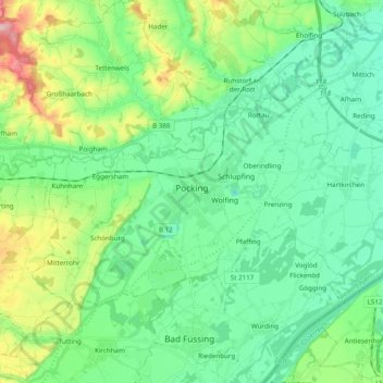
Name: Pocking topographic map, elevation, terrain.
Location: Pocking, Landkreis Passau, Bayern, 94060, Deutschland (48.36106 13.22918 48.43935 13.42317)
Average elevation: 1,112 ft
Minimum elevation: 942 ft
Maximum elevation: 1,604 ft
Other topographic maps
Click on a map to view its topography, its elevation and its terrain.
Gottsdorf
Deutschland > Bayern > Landkreis Passau
Bachhäusl | Berghof | Brunnreut | Dienberg | Diendorf | Dürrmühle | Eck | Eckersäg | Eckerstampf | Eckmühle | Endsfelden | Feldhäusl | Ficht | Fichtwiesen | Friedlgrub | Gammertshof | Gebrechtshof | Gebrechtsmühle | Glotzing | Gotting | Gottsdorf | Grögöd | Grub | Grünau | Habersdorf | Hamet |…
Average elevation: 1,900 ft
Forsthub
Deutschland > Bayern > Landkreis Passau > Bad Griesbach i.Rottal > St. Salvator
Average elevation: 1,394 ft
Haidenhof
Deutschland > Bayern > Landkreis Passau > Hauzenberg > Ruhmannsdorf
Average elevation: 1,808 ft
Grafenmühl
Deutschland > Bayern > Landkreis Passau > Vilshofen an der Donau > Liessing
Average elevation: 1,161 ft
Hauzenberg
Deutschland > Bayern > Landkreis Passau > Hauzenberg > Hauzenberg
Average elevation: 1,952 ft
Singham
Deutschland > Bayern > Landkreis Passau > Bad Griesbach i.Rottal > Karpfham > Singham
Average elevation: 1,184 ft
Oberiglbach
Deutschland > Bayern > Landkreis Passau > Ortenburg > Oberiglbach
Average elevation: 1,276 ft
Kaltrum
Deutschland > Bayern > Landkreis Passau > Hauzenberg > Hintertiessen
Average elevation: 2,064 ft
Jägerwirth
Deutschland > Bayern > Landkreis Passau
Jägerwirth liegt in einer Höhenlage von 476 Metern am Rand des Neuburger Waldes etwa drei Kilometer nordwestlich von Fürstenzell. Die Pfarrkirche des Ortes ist über mehrere Kilometer zu sehen.
Average elevation: 1,394 ft
Kramersdorf
Deutschland > Bayern > Landkreis Passau > Hauzenberg > Raßreuth
Average elevation: 2,064 ft
Steinkart
Deutschland > Bayern > Landkreis Passau > Bad Griesbach i.Rottal
Average elevation: 1,476 ft
Adlmörting
Deutschland > Bayern > Landkreis Passau > Bad Griesbach i.Rottal > Reutern
Average elevation: 1,437 ft
Reut
Deutschland > Bayern > Landkreis Passau > Vilshofen an der Donau > Aunkirchen
Average elevation: 1,155 ft
Sollasöd
Deutschland > Bayern > Landkreis Passau > Vilshofen an der Donau > Lindach
Average elevation: 1,175 ft
Unteriglbach
Deutschland > Bayern > Landkreis Passau > Ortenburg
Wie alle auf -bach endenden Orte bezeichnet auch der Name Iglbach zunächst ein Gewässer, an dem die Siedlung liegt. Die „-bach“-Orte gelten als Zeugen frühen Eindringens ins Waldland. In der Topographie Baierns von Philipp Apian, welche um das Jahr 1580 in lateinischer Sprache entstand, wird das Dorf…
Average elevation: 1,224 ft
Reuth
Deutschland > Bayern > Landkreis Passau > Fürstenstein > Fürstenstein
Average elevation: 1,545 ft
Eisenthal
Deutschland > Bayern > Landkreis Passau > Bad Griesbach i.Rottal > Singham
Average elevation: 1,181 ft
Alkofen
Deutschland > Bayern > Landkreis Passau > Vilshofen an der Donau
Alkofen entstand aus den Bestrebungen des bayerischen Kurfürsten, seine Länder zu „peupelieren“, das heißt, auf öffentlichem Grund Siedlerstellungen zu schaffen, bäuerliche Kleinbetriebe, die eine Familie ernähren sollten. Vor 1800 gab es nur die Weiler Alkofen, Daxlarn, Dorf, einige Einödhöfe und…
Average elevation: 1,224 ft
Bad Höhenstadt
Deutschland > Bayern > Landkreis Passau
Bad Höhenstadt ist ein Gemeindeteil, ehemaliger Wallfahrtsort und ehemaliger Kurort im Markt Fürstenzell im niederbayerischen Landkreis Passau.
Average elevation: 1,184 ft
Neumühle
Deutschland > Bayern > Landkreis Passau > Hauzenberg > Innerhartsberg
Average elevation: 1,480 ft
Vilshofen an der Donau
Deutschland > Bayern > Landkreis Passau > Vilshofen an der Donau
Average elevation: 1,214 ft
Dürnöd
Deutschland > Bayern > Landkreis Passau > Bad Füssing > Bad Füssing
Average elevation: 1,076 ft
Eden
Deutschland > Bayern > Landkreis Passau > Bad Griesbach i.Rottal > Parzham
Average elevation: 1,335 ft
Oberham
Deutschland > Bayern > Landkreis Passau > Bad Griesbach i.Rottal > Schwaim
Average elevation: 1,194 ft
Kollbrunn
Deutschland > Bayern > Landkreis Passau > Fürstenzell > Kollbrunn
Average elevation: 1,362 ft