Geolocate

Cosby topographic map

Click on the map to display elevation.

About this map

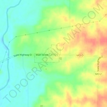
Name: Cosby topographic map, elevation, terrain.

Location: Cosby, Andrew County, Missouri, 64436, United States (39.86209 -94.68455 39.86658 -94.67605)

Average elevation: 932 ft

Minimum elevation: 853 ft

Maximum elevation: 1,030 ft

Andrew County trails, hiking, mountain biking, running and outdoor activities

Other topographic maps

Click on a map to view its topography, its elevation and its terrain.

Empire Prairie

United States > Missouri > Andrew County

Average elevation: 1,076 ft

Riggin Branch

United States > Missouri > Andrew County

Average elevation: 945 ft

Avenue City

United States > Missouri > Andrew County

Average elevation: 925 ft

Flag Springs

United States > Missouri > Andrew County

Average elevation: 1,030 ft

Fountainbleau

United States > Missouri > Andrew County

Average elevation: 981 ft

Kodiak

United States > Missouri > Andrew County

Average elevation: 994 ft

Nodaway

United States > Missouri > Andrew County

Average elevation: 892 ft

Rankin

United States > Missouri > Andrew County

Average elevation: 988 ft

Rochester

United States > Missouri > Andrew County

Average elevation: 945 ft

Whitesville

United States > Missouri > Andrew County

Average elevation: 961 ft

Wyeth

United States > Missouri > Andrew County

Average elevation: 958 ft

Gear up for your next adventure:

📶Vehicle Signal Boosters - Improve reception in rural areas while driving to trailheads
🔋Solar Power Banks - Keep your GPS and phone charged in remote wilderness areas
🧭Hiking Compass - Precision compass for reliable navigation in the wilderness
🚗GPS Dash Cams - Record your scenic drives through mountain passes and canyons
🧷Carabiner Set - Durable clips for gear attachment

As an Amazon Associate, this site earns from qualifying purchases at no extra cost to you.