Geolocate

Andabamba topographic map

Click on the map to display elevation.

About this map

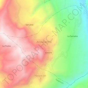
Name: Andabamba topographic map, elevation, terrain.

Location: Andabamba, Province of Santa Cruz, Cajamarca, Peru (-6.68120 -78.83350 -6.64628 -78.79580)

Average elevation: 7,936 ft

Minimum elevation: 6,434 ft

Maximum elevation: 9,209 ft

Other topographic maps

Click on a map to view its topography, its elevation and its terrain.

Santa Cruz

Peru > Cajamarca

Average elevation: 1,677 ft

El Cardon

Peru > Cajamarca > Cutervo

Average elevation: 7,598 ft

Callancas

Peru > Cajamarca > San Pablo

Average elevation: 9,921 ft

Cruz De Chalpon

Peru > Cajamarca > San Ignacio

Average elevation: 4,882 ft

Regalado

Peru > Cajamarca > Tumbaden

Average elevation: 10,840 ft

Alto Otuzco

Peru > Cajamarca > Los Baños del Inca > Otuzco

Average elevation: 9,275 ft

La Cordillera

Peru > Cajamarca > San Ignacio > La Cordillera

Average elevation: 4,465 ft

Yube

Peru > Cajamarca > Callayuc

Average elevation: 5,213 ft

Gear up for your next adventure:

🥄Camping Utensil Set - Lightweight utensils for outdoor meals
🔥Fast-Boil Camping Stoves - Efficient cooking systems for quick trail meals
💧Water Filtration Bottles - Safely drink from streams and lakes while exploring
🧯Emergency Survival Kit - All‑in‑one survival essentials for the backcountry
🚗GPS Dash Cams - Record your scenic drives through mountain passes and canyons

As an Amazon Associate, this site earns from qualifying purchases at no extra cost to you.