
Make a donation
Gear up for your next adventure:
As an Amazon Associate, this site earns from qualifying purchases at no extra cost to you.
Tha Sala topographic map
Click on the map to display elevation.
Make a donation
Gear up for your next adventure:
As an Amazon Associate, this site earns from qualifying purchases at no extra cost to you.
About this map
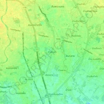
Name: Tha Sala topographic map, elevation, terrain.
Average elevation: 997 ft
Minimum elevation: 965 ft
Maximum elevation: 1,027 ft
Make a donation
Gear up for your next adventure:
As an Amazon Associate, this site earns from qualifying purchases at no extra cost to you.
Other topographic maps
Click on a map to view its topography, its elevation and its terrain.
Thailand
Thailand comprises several distinct geographic regions, partly corresponding to the provincial groups. The north of the country is the mountainous area of the Thai highlands, with the highest point being Doi Inthanon in the Thanon Thong Chai Range at 2,565 metres (8,415 ft) elevation. The northeast, Isan,…
Average elevation: 512 ft
Songkhla Province
The province is on the Malay Peninsula, on the coast of the Gulf of Thailand. The highest elevation is Khao Mai Kaeo at 821 meters.
Average elevation: 164 ft
Make a donation
Gear up for your next adventure:
As an Amazon Associate, this site earns from qualifying purchases at no extra cost to you.
Chiang Mai Province
Chiang Mai province is about 685 km (426 mi) from Bangkok in the Mae Ping River basin and is on average at 300 m (1,000 ft) elevation. Surrounded by the mountain ranges of the Thai highlands, it covers an area of approximately 20,107 km2 (8,000 sq mi). The mountains of the Daen Lao Range…
Average elevation: 2,129 ft
Make a donation
Gear up for your next adventure:
As an Amazon Associate, this site earns from qualifying purchases at no extra cost to you.
Surin Province
Surin lies at the center of the southern edge of the Khorat Plateau, a relatively low-lying interior region isolated from the rest of Southeast Asia by surrounding mountain ranges. The south of the province is dominated by the Dongrek mountain range, the escarpment of which demarcates the watershed boundaries…
Average elevation: 531 ft
Make a donation
Gear up for your next adventure:
As an Amazon Associate, this site earns from qualifying purchases at no extra cost to you.
Pak Tha Subdistrict
Thailand > Pak Tha Subdistrict Administrative Organization
Average elevation: 23 ft
Make a donation
Gear up for your next adventure:
As an Amazon Associate, this site earns from qualifying purchases at no extra cost to you.
Ratchaburi Province
The area of Ratchaburi province is divided into three parts. First, the border in the west which is shared with Myanmar and is about 60 kilometres (37 mi) long. The second contains the Tenasserim mountains and forests with an elevation of about 200–300 meters. The central area of the province is rich in…
Average elevation: 902 ft
Make a donation
Gear up for your next adventure:
As an Amazon Associate, this site earns from qualifying purchases at no extra cost to you.
Make a donation
Gear up for your next adventure:
As an Amazon Associate, this site earns from qualifying purchases at no extra cost to you.
Make a donation
Gear up for your next adventure:
As an Amazon Associate, this site earns from qualifying purchases at no extra cost to you.
Make a donation
Gear up for your next adventure:
As an Amazon Associate, this site earns from qualifying purchases at no extra cost to you.
Tham Luang-Khun Nam Nang Non Forest Park
Thailand > Mae Sai district > Ban Pha Hi
Average elevation: 2,169 ft
Make a donation
Gear up for your next adventure:
As an Amazon Associate, this site earns from qualifying purchases at no extra cost to you.
Nakhon Nayok Province
The northern part of the province is in the Sankamphaeng Range, the southern prolongation of the Dong Phaya Yen Mountains, with the highest elevation the 1,292-meter-high Yod Khao Kiew. Most of that area is covered by the Khao Yai National Park, 2,166 km2 (836 sq mi), along with three other national parks,…
Average elevation: 600 ft
Make a donation
Gear up for your next adventure:
As an Amazon Associate, this site earns from qualifying purchases at no extra cost to you.
Bang Kruai Subdistrict
Thailand > Nonthaburi Province > Bang Kruai District > Bang Kruai Town Municipality
Average elevation: 16 ft
Make a donation
Gear up for your next adventure:
As an Amazon Associate, this site earns from qualifying purchases at no extra cost to you.
Make a donation
Gear up for your next adventure:
As an Amazon Associate, this site earns from qualifying purchases at no extra cost to you.
Bang Chalong Subdistrict
Thailand > Samut Prakan Province > Bang Chalong Subdistrict
Average elevation: 13 ft
Maha Phram Subdistrict Municipality
Thailand > Phra Nakhon Si Ayutthaya Province > Bang Ban District
Average elevation: 16 ft
Make a donation
Gear up for your next adventure:
As an Amazon Associate, this site earns from qualifying purchases at no extra cost to you.
Khu Khot Town Municipality
Thailand > Pathum Thani Province > Lam Luk Ka District > Khu Khot Town Municipality
Average elevation: 16 ft
Make a donation
Gear up for your next adventure:
As an Amazon Associate, this site earns from qualifying purchases at no extra cost to you.
Tha Khlong Town Municipality
Thailand > Pathum Thani Province > Khlong Luang District > Tha Khlong Town Municipality
Average elevation: 13 ft
Khlong Chik Subdistrict
Thailand > Phra Nakhon Si Ayutthaya Province > Bang Pa-in District > Khlong Chik Subdistrict
Average elevation: 13 ft
Make a donation
Gear up for your next adventure:
As an Amazon Associate, this site earns from qualifying purchases at no extra cost to you.
Phra Pradaeng Town Municipality
Thailand > Samut Prakan Province > Phra Pradaeng District > Phra Pradaeng Town Municipality
Average elevation: 13 ft
Waeng Noi Municipality Health park
Thailand > Khon Kaen Province > Waeng Noi
Average elevation: 630 ft
Phra Nakhon Si Ayutthaya City Municipality
Thailand > Phra Nakhon Si Ayutthaya Province > Phra Nakhon Si Ayutthaya District
Average elevation: 23 ft
Make a donation
Gear up for your next adventure:
As an Amazon Associate, this site earns from qualifying purchases at no extra cost to you.
Mu 3
Thailand > Phra Nakhon Si Ayutthaya Province > Phra Nakhon Si Ayutthaya District > Khlong Suan Phlu Subdistrict
Average elevation: 16 ft
Make a donation
Gear up for your next adventure:
As an Amazon Associate, this site earns from qualifying purchases at no extra cost to you.
Ban Chang Subdistrict Administrative Organization
Thailand > Pathum Thani Province
Average elevation: 13 ft
Make a donation
Gear up for your next adventure:
As an Amazon Associate, this site earns from qualifying purchases at no extra cost to you.