
Make a donation
Gear up for your next adventure:
As an Amazon Associate, this site earns from qualifying purchases at no extra cost to you.
Nsanje topographic map
Click on the map to display elevation.
Make a donation
Gear up for your next adventure:
As an Amazon Associate, this site earns from qualifying purchases at no extra cost to you.
Nsanje
Nsanje is the southernmost district in Malawi and lies in the Lower Shire River Valley. It straddles the Shire River in the north (the river forms most of Nsanje's eastern boundary) and is surrounded by Mozambique. Elevation is around 200 feet (61 m) ASL except for some hills in the south-western part of the district which reach near to 2,000 feet (610 m) ASL. Mwabvi Game Reserve lies in the north-western part of the district and can be accessed from Bangula or Sorgin (both along the M-1 road) Elephant Marsh lies partially in the northern part of the district and can be accessed for tours via the eastern bank road. Tours start from the village of James.
Make a donation
Gear up for your next adventure:
As an Amazon Associate, this site earns from qualifying purchases at no extra cost to you.
About this map
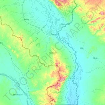
Name: Nsanje topographic map, elevation, terrain.
Location: Nsanje, Southern Region, Malawi, Malawi (-17.12960 34.89497 -16.31016 35.31473)
Average elevation: 564 ft
Minimum elevation: 102 ft
Maximum elevation: 3,166 ft
Make a donation
Gear up for your next adventure:
As an Amazon Associate, this site earns from qualifying purchases at no extra cost to you.
Other topographic maps
Click on a map to view its topography, its elevation and its terrain.
Mchinji
Mchinji Boma lies at an elevation of 1,182 metres (3,877 ft), 12 kilometres (7.5 mi) from the Zambian border. It is situated 12.4 km (7.7 mi) away from Katambo, 3.5 km (2.2 mi) away from Kadulama Lambo, 2.3 km (1.4 mi) away from Daka and 4.5 km (2.8 mi) away from Tsumba.
Average elevation: 3,967 ft
Mount Mulanje
Mulanje Massif rises abruptly from the plains to a high plateau at 1800-1900m, surmounted by rocky peaks. Sapitwa Peak is the highest peak on the plateau and the highest peak in Malawi, with an altitude of 3002m above sea level. It is surrounded by densely populated plains situated at 600m-700m above sea level.
Average elevation: 3,796 ft
Make a donation
Gear up for your next adventure:
As an Amazon Associate, this site earns from qualifying purchases at no extra cost to you.
Make a donation
Gear up for your next adventure:
As an Amazon Associate, this site earns from qualifying purchases at no extra cost to you.
Make a donation
Gear up for your next adventure:
As an Amazon Associate, this site earns from qualifying purchases at no extra cost to you.