
Make a donation
Gear up for your next adventure:
As an Amazon Associate, this site earns from qualifying purchases at no extra cost to you.
Walchsee topographic map
Click on the map to display elevation.
Make a donation
Gear up for your next adventure:
As an Amazon Associate, this site earns from qualifying purchases at no extra cost to you.
About this map
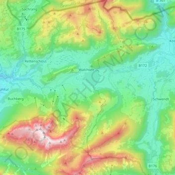
Name: Walchsee topographic map, elevation, terrain.
Location: Walchsee, Bezirk Kufstein, Tirol, 6344, Österreich (47.58184 12.27446 47.69706 12.35525)
Average elevation: 3,186 ft
Minimum elevation: 1,706 ft
Maximum elevation: 6,486 ft
Make a donation
Gear up for your next adventure:
As an Amazon Associate, this site earns from qualifying purchases at no extra cost to you.
Other topographic maps
Click on a map to view its topography, its elevation and its terrain.
Hinteres Sonnwendjoch
Österreich > Tirol > Bezirk Kufstein > Thiersee
Das Hintere Sonnwendjoch in Tirol ist mit 1986 m ü. A. der höchste Berg des Mangfallgebirges, eines Teilgebirges der Bayerischen Voralpen. Da der südlich gelegene Teil der Brandenberger Alpen niedriger ist, bietet der Gipfel trotz seiner relativ geringen Höhe hervorragende Ausblicke auf die Zentralalpen.…
Average elevation: 4,918 ft
Make a donation
Gear up for your next adventure:
As an Amazon Associate, this site earns from qualifying purchases at no extra cost to you.
Make a donation
Gear up for your next adventure:
As an Amazon Associate, this site earns from qualifying purchases at no extra cost to you.
Oberau
Österreich > Tirol > Bezirk Kufstein > Wildschönau
Die Wildschönau beginnt im Osten mit Niederau und Straßenverbindungen nach Wörgl und Hopfgarten im Brixental, nach Westen hin verläuft sie aufsteigend zu einer Wasserscheide, über die sich Oberau zur Wildschönauer Ache und dem Ortsteil Mühltal hinzieht. Die Ache fließt von Süd nach Nord, vom…
Average elevation: 3,615 ft
Wiedersberger Horn
Österreich > Tirol > Bezirk Kufstein > Alpbach
Das Wiedersberger Horn ist ein Berg im Alpbachtal. Der Gipfel hat eine Höhe von 2127 m ü. A. Das Wiedersberger Horn ist aus dem Alpbachtal mit Seilbahnen erschlossen und die Bergflanken werden als Skigebiet genutzt. Im Winter ist die Besteigung des Gipfels bei sicheren Schneeverhältnissen unproblematisch.…
Average elevation: 5,636 ft
Make a donation
Gear up for your next adventure:
As an Amazon Associate, this site earns from qualifying purchases at no extra cost to you.
Make a donation
Gear up for your next adventure:
As an Amazon Associate, this site earns from qualifying purchases at no extra cost to you.
Make a donation
Gear up for your next adventure:
As an Amazon Associate, this site earns from qualifying purchases at no extra cost to you.
Alpbachtal
Österreich > Tirol > Bezirk Kufstein > Hygna
Höhere und touristisch gut erschlossene Gipfel im Alpbachtal sind
Average elevation: 4,078 ft
Make a donation
Gear up for your next adventure:
As an Amazon Associate, this site earns from qualifying purchases at no extra cost to you.
Alpmoosau-Schneeberg
Österreich > Tirol > Bezirk Kufstein > Thiersee > Mitterland
Average elevation: 2,982 ft
Make a donation
Gear up for your next adventure:
As an Amazon Associate, this site earns from qualifying purchases at no extra cost to you.
Make a donation
Gear up for your next adventure:
As an Amazon Associate, this site earns from qualifying purchases at no extra cost to you.