
Carrollton topographic map
Click on the map to display elevation.
About this map
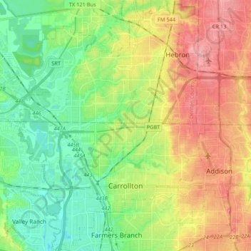
Name: Carrollton topographic map, elevation, terrain.
Location: Carrollton, Dallas County, Texas, United States (32.91810 -96.95861 33.05518 -96.83527)
Average elevation: 538 ft
Minimum elevation: 407 ft
Maximum elevation: 715 ft
Dallas County trails, hiking, mountain biking, running and outdoor activities
Other topographic maps
Click on a map to view its topography, its elevation and its terrain.
Dallas
United States > Texas > Dallas County > Dallas
Dallas and its surrounding area are mostly flat. The city lies at elevations ranging from 450 to 550 feet (137 to 168 m) above sea level. The western edge of the Austin Chalk Formation, a limestone escarpment (also known as the "White Rock Escarpment"), rises 230 feet (70 m) and runs roughly north–south…
Average elevation: 518 ft