
Village of Freeville topographic map
Interactive map
Click on the map to display elevation.
About this map
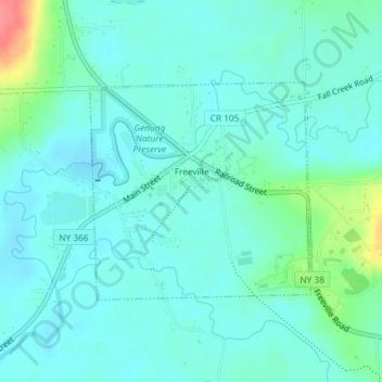
Name: Village of Freeville topographic map, elevation, terrain.
Average elevation: 1,056 ft
Minimum elevation: 1,010 ft
Maximum elevation: 1,243 ft
Other topographic maps
Click on a map to view its topography, its elevation and its terrain.
City of Ithaca
United States > New York > Tompkins County
City of Ithaca, Tompkins County, New York, United States
Average elevation: 640 ft
Cass Park
United States > New York > Tompkins County > City of Ithaca
Cass Park, 701, Ward 1, City of Ithaca, Tompkins County, New York, 14850, United States
Average elevation: 512 ft
West Groton
United States > New York > Tompkins County > Town of Groton
West Groton, Town of Groton, Tompkins County, New York, 13092, United States
Average elevation: 1,230 ft
Terpening Corners
United States > New York > Tompkins County > South Lansing
Terpening Corners, South Lansing, Town of Lansing, Tompkins County, New York, United States
Average elevation: 945 ft
Northeast Ithaca
United States > New York > Tompkins County > Town of Ithaca
Northeast Ithaca, Town of Ithaca, Tompkins County, New York, United States
Average elevation: 1,001 ft
Hayts Corner
United States > New York > Tompkins County > Town of Ithaca
Hayts Corner, Town of Ithaca, Tompkins County, New York, 14851, United States
Average elevation: 840 ft
Town of Lansing
United States > New York > Tompkins County
Town of Lansing, Tompkins County, New York, 14882, United States
Average elevation: 1,010 ft
Shindagin Hollow State Forest
United States > New York > Tompkins County > Town of Caroline
Shindagin Hollow State Forest, Town of Caroline, Tompkins County, New York, United States
Average elevation: 1,499 ft
Caroline Depot
United States > New York > Tompkins County > Town of Caroline
Caroline Depot, Town of Caroline, Tompkins County, New York, 14817, United States
Average elevation: 1,207 ft
Brooktondale
United States > New York > Tompkins County
Brooktondale, Town of Caroline, Tompkins County, New York, United States
Average elevation: 1,060 ft
Town of Newfield
United States > New York > Tompkins County
Town of Newfield, Tompkins County, New York, 14867, United States
Average elevation: 1,398 ft
Town of Ithaca
United States > New York > Tompkins County
Town of Ithaca, Tompkins County, New York, United States
Average elevation: 945 ft
Danby State Forest
United States > New York > Tompkins County > Town of Danby
Danby State Forest, Town of Danby, Tompkins County, New York, United States
Average elevation: 1,368 ft
Village of Groton
United States > New York > Tompkins County
Village of Groton, Town of Groton, Tompkins County, New York, United States
Average elevation: 1,184 ft
Ithaca
United States > New York > Tompkins County > Ithaca
Ithaca, Ithaca Town, Tompkins County, New York, 14850, United States
Average elevation: 1,214 ft
Speedsville
United States > New York > Tompkins County > Town of Caroline
Speedsville, Town of Caroline, Tompkins County, New York, United States
Average elevation: 1,312 ft
Village of Cayuga Heights
United States > New York > Tompkins County > Town of Ithaca > Village of Cayuga Heights
Village of Cayuga Heights, Town of Ithaca, Tompkins County, New York, United States
Average elevation: 768 ft
Town of Dryden
United States > New York > Tompkins County
Town of Dryden, Tompkins County, New York, United States
Average elevation: 1,411 ft
Village of Trumansburg
United States > New York > Tompkins County
Village of Trumansburg, Town of Ulysses, Tompkins County, New York, 14854, United States
Average elevation: 984 ft
Lansing
United States > New York > Tompkins County > Lansing > Lansing
Lansing, Lansing Town, Tompkins County, New York, 14853, United States
Average elevation: 860 ft
Caroline
United States > New York > Tompkins County > Caroline
Caroline, Caroline Town, Tompkins County, New York, United States
Average elevation: 1,516 ft
East Ithaca
United States > New York > Tompkins County > Ithaca > East Ithaca
East Ithaca, Ithaca, Ithaca Town, Tompkins County, New York, 14853, United States
Average elevation: 768 ft
Village of Lansing
United States > New York > Tompkins County
Village of Lansing, Town of Lansing, Tompkins County, New York, United States
Average elevation: 965 ft
Varna
United States > New York > Tompkins County > Varna
Varna, Dryden Town, Tompkins County, New York, 14853, United States
Average elevation: 1,047 ft