Geolocate

Volcano Mountain topographic map

Click on the map to display elevation.

About this map

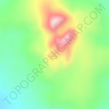
Name: Volcano Mountain topographic map, elevation, terrain.

Location: Volcano Mountain, Yukon, Canada (62.91730 -137.38145 62.91740 -137.38135)

Average elevation: 3,084 ft

Minimum elevation: 2,480 ft

Maximum elevation: 4,039 ft

Other topographic maps

Click on a map to view its topography, its elevation and its terrain.

Porter Creek

Canada > Yukon > Whitehorse

Average elevation: 2,329 ft

Haines Junction

Canada > Yukon

Average elevation: 2,060 ft

Burwash Landing

Canada > Yukon > Burwash Landing

Average elevation: 2,717 ft

Carmacks

Canada > Yukon

Average elevation: 2,034 ft

Teslin Post 13

Canada > Yukon

Average elevation: 2,280 ft

Bear Creek

Canada > Yukon

Average elevation: 2,116 ft

Destruction Bay

Canada > Yukon > Destruction Bay

Average elevation: 2,930 ft

Beaver Creek

Canada > Yukon > Beaver Creek

Average elevation: 2,195 ft

Sambo Creek

Canada > Yukon

Average elevation: 2,218 ft

Victoria Lake

Canada > Yukon

Average elevation: 3,192 ft

Teslin

Canada > Yukon > Teslin

Average elevation: 2,300 ft

Gear up for your next adventure:

🛠️Outdoor Gear Repair Kit - Essential tools to fix gear on the trail
⛑️Personal Locator Beacon - Safety beacon for emergencies
🎒Gear Packing Cubes - Organize your backpack efficiently
🥩Freeze-Dried Meals - Nutritious and lightweight food for remote expeditions
🌲Outdoor Survival Books - Best books on survival skills

As an Amazon Associate, this site earns from qualifying purchases at no extra cost to you.