Geolocate

Davis Store topographic map

Click on the map to display elevation.

About this map

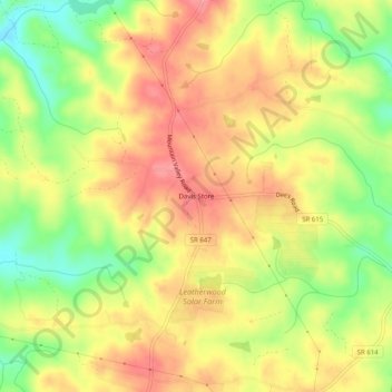
Name: Davis Store topographic map, elevation, terrain.

Location: Davis Store, Henry County, Virginia, United States (36.67569 -79.72809 36.71569 -79.68809)

Average elevation: 919 ft

Minimum elevation: 751 ft

Maximum elevation: 1,043 ft

Henry County trails, hiking, mountain biking, running and outdoor activities

Other topographic maps

Click on a map to view its topography, its elevation and its terrain.

Oak Level

United States > Virginia > Henry County

Average elevation: 1,073 ft

Sandy Level

United States > Virginia > Henry County > Sandy Level

Average elevation: 689 ft

Stanleytown

United States > Virginia > Henry County

Average elevation: 850 ft

Chatmoss

United States > Virginia > Henry County

Average elevation: 801 ft

Laurel Park

United States > Virginia > Henry County

Average elevation: 748 ft

Gear up for your next adventure:

🦶Hiking Gaiters - Keep debris and water out of your boots
🥄Camping Utensil Set - Lightweight utensils for outdoor meals
🦟Ultrasonic Repellers - Create a bug-free zone at your camp or rest stop
🧭Outdoor Navigation Book - Learn advanced navigation skills
📦Dry Bags Set - Waterproof storage for electronics and clothes

As an Amazon Associate, this site earns from qualifying purchases at no extra cost to you.