Geolocate

Payson topographic map

Click on the map to display elevation.

About this map

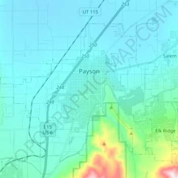
Name: Payson topographic map, elevation, terrain.

Location: Payson, Utah County, Utah, 84651, United States (39.99811 -111.81537 40.07076 -111.68649)

Average elevation: 4,833 ft

Minimum elevation: 4,498 ft

Maximum elevation: 7,461 ft

Utah County trails, hiking, mountain biking, running and outdoor activities

Other topographic maps

Click on a map to view its topography, its elevation and its terrain.

Nutty Putty Cave

United States > Utah > Utah County

Average elevation: 5,075 ft

Spanish Fork Peak

United States > Utah > Utah County

Average elevation: 8,924 ft

Birdseye

United States > Utah > Utah County

Average elevation: 5,840 ft

Bald Mountain Overlook

United States > Utah > Utah County

Average elevation: 8,373 ft

Mount Timpanogos

United States > Utah > Utah County

Average elevation: 10,299 ft

Curtis

United States > Utah > Utah County > Orem

Average elevation: 4,701 ft

Lone Peak

United States > Utah > Utah County

Average elevation: 9,885 ft

Caryhurst

United States > Utah > Utah County > Provo

Average elevation: 5,128 ft

Mount Timpanogos

United States > Utah > Utah County

Average elevation: 10,299 ft

Townsend

United States > Utah > Utah County > Genola

Average elevation: 4,718 ft

Pleasant View

United States > Utah > Utah County > Provo

Average elevation: 4,744 ft

Lone Peak

United States > Utah > Utah County

Average elevation: 9,885 ft

Gear up for your next adventure:

📦Gear Storage Bags - Organize and protect outdoor equipment
🏔️Mountain Trail Maps - High‑detail maps for popular peaks
🥘Titanium Cookware - Durable, featherlight pots and pans for backpacking
📷Action Cameras - Rugged cameras to document your journeys across rugged terrain
🧣Merino Neck Gaiters - Multi-functional headwear for wind and sun protection

As an Amazon Associate, this site earns from qualifying purchases at no extra cost to you.