
Kent topographic map
Click on the map to display elevation.
Kent
Kent was also the location of the largest number of art schools in the country during the nineteenth century, estimated by the art historian David Haste, to approach two hundred. This is believed to be the result of Kent being a front line county during the Napoleonic Wars. At this time, before the invention of photography, draughtsmen were used to draw maps and topographical representations of the fields of battle, and after the wars ended many of these settled permanently in the county in which they had been based. Once the idea of art schools had been established, even in small towns in Kent, the tradition continued, although most of the schools were very small one-man operations, each teaching a small number of daughters of the upper classes how to draw and make watercolour paintings. Nonetheless, some of these small art schools developed into much larger organisations, including Canterbury College of Art, founded by Thomas Sidney Cooper in 1868, which is today the University for the Creative Arts.
About this map
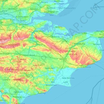
Name: Kent topographic map, elevation, terrain.
Location: Kent, England, United Kingdom (50.91048 0.03352 51.50368 1.45177)
Average elevation: 121 ft
Minimum elevation: -10 ft
Maximum elevation: 856 ft
Other topographic maps
Click on a map to view its topography, its elevation and its terrain.
Cambridge
United Kingdom > England > Cambridge
The city, like most of the UK, has a maritime climate highly influenced by the Gulf Stream. Located in the driest region of Britain, Cambridge's rainfall averages around 570 mm (22.44 in) per year, around half the national average, with some years occasionally falling into the semi-arid (under 500 mm (19.69…
Average elevation: 59 ft
Farnborough
United Kingdom > England > Hampshire > Rushmoor
Farnborough is located in the northeastern corner of the county of Hampshire, near the border with Surrey. The town occupies a valley setting, with the main urban area situated between the River Blackwater to the east and higher ground to the west. The topography gradually rises from the valley floor, reaching…
Average elevation: 269 ft
Stoke-on-Trent
United Kingdom > England > Stoke-on-Trent > Stoke-on-Trent
In 1919, the borough proposed to expand further and annex the neighbouring borough of Newcastle-under-Lyme and the Wolstanton United Urban District, both to the west of Stoke. This never took place, due to strong objections from Newcastle Corporation. A further attempt was made in 1930, with the promotion of…
Average elevation: 525 ft
Catcliffe
United Kingdom > England > Rotherham
The Catcliffe Glass Cone, part of the previous William Fenney's glassworks, is on Main Street. The centre of the village is dominated by a nine-arch viaduct that was built in 1901 to carry the Sheffield District Railway across the River Rother. Catcliffe Flash, to the south of the village, is a local nature…
Average elevation: 190 ft
Stratton Brook
United Kingdom > England > Surrey > Tandridge > Godstone > Church Town
Average elevation: 384 ft
Treeton
United Kingdom > England > Rotherham
Catcliffe Flash, to the west of the village, is a local nature reserve that is made up of a lake and marshland formed as the elevation of the land beside the River Rother dropped due to coal mining subsidence. To the south-east of the village are three areas of ancient woodland, Treeton Wood, Hail Mary Hill…
Average elevation: 190 ft
Newcastle-under-Lyme
United Kingdom > England > Staffordshire > Newcastle-under-Lyme
Average elevation: 482 ft
Bradford
Bradford is located at 53°45′00″N 01°50′00″W / 53.75000°N 1.83333°W / 53.75000; -1.83333 (53.7500, -1.8333)1. Topographically, it is located in the eastern moorland region of the South Pennines.
Average elevation: 548 ft
Kings Heath
United Kingdom > England > West Midlands Combined Authority > Birmingham > Kings Heath
Average elevation: 466 ft
City of London
United Kingdom > England > City of London > City of London
The elevation of the City ranges from sea level at the Thames to 21.6 metres (71 ft) at the junction of High Holborn and Chancery Lane. Two small but notable hills are within the historic core, Ludgate Hill to the west and Cornhill to the east. Between them ran the Walbrook, one of the many "lost" rivers or…
Average elevation: 138 ft
Leeds
Lying in the eastern foothills of the Pennines, there is a significant variation in elevation within the city's built-up area. The district ranges from 1,115 feet (340 m) in the far west on the slopes of Ilkley Moor to about 33 feet (10 m) where the rivers Aire and Wharfe cross the eastern boundary. Land rises…
Average elevation: 308 ft
St Albans
United Kingdom > England > Hertfordshire > St Albans
St Albans was an ancient borough created following the dissolution of the monastery in 1539. It consisted of the ancient parish of St Albans (also known as the Abbey parish) and parts of St Michael and St Peter. The municipal corporation was reformed by the Municipal Corporations Act 1835 and the boundary was…
Average elevation: 328 ft
Richmond
United Kingdom > England > London
The town centre lies just below 33 ft (10m) above sea level. South of the town centre, rising from Richmond Bridge to an elevation of 165 ft (50m), is Richmond Hill. Just beyond the summit of Richmond Hill is Richmond Park, an area of 2,360 acres (9.55 km2; 3.7 sq mi) of wild heath and woodland originally…
Average elevation: 56 ft
Exeter
United Kingdom > England > Devon > Exeter
The city of Exeter was established on the eastern bank of the River Exe on a ridge of land backed by a steep hill. It is at this point that the Exe, having just been joined by the River Creedy, opens onto a wide flood plain and estuary which results in quite common flooding. Historically this was the lowest…
Average elevation: 325 ft
Cambridge
United Kingdom > England > Cambridgeshire
The city, like most of the UK, has a maritime climate highly influenced by the Gulf Stream. Located in the driest region of Britain, Cambridge's rainfall averages around 570 mm (22.44 in) per year, around half the national average, The driest recent year was in 2011 with 380.4 mm (14.98 in) of rain at the…
Average elevation: 108 ft
West Byfleet
United Kingdom > England > Surrey > Woking
The surface undulates gently from the west to the east, where West Byfleet's land is drained in the parish of Byfleet itself by the River Wey. Soil ranges from sandy acidic soil in the west to more alluvial soil in the east, underlain by a mixture of gravel and clay. Elevations range from 18m Above Ordnance…
Average elevation: 85 ft
Camberley
United Kingdom > England > Surrey > Surrey Heath
The Staff College, to the north of Camberley town centre, is part of the Joint Services Command and Staff College, which provides training and education for established officers in the British Armed Forces and civil servants in the Ministry of Defence. The institution has its origins in the Royal Military…
Average elevation: 289 ft
Towcester
United Kingdom > England > Towcester
St. Lawrence's C of E Church, stands in the middle of the town. It has a 12th-century Norman transitional ground plan and foundation, probably laid over a Saxon 10th century stone building. Its ecclesiastical heritage may well relate back to Roman times as St Lawrence was patron saint of the Roman legions. The…
Average elevation: 384 ft
Swindon
United Kingdom > England > Swindon
Swindon has an oceanic climate (Cfb in the Köppen climate classification), like the vast majority of the British Isles, with cool winters and warm summers. The nearest official weather station is RAF Lyneham, about 10 miles (16 km) west southwest of Swindon town centre. The weather station's elevation is 145…
Average elevation: 354 ft
Wardy Hill
United Kingdom > England > Cambridgeshire > East Cambridgeshire > Coveney
Average elevation: 13 ft
Windsor Castle
United Kingdom > England > Royal Borough of Windsor and Maidenhead > Windsor > Clewer Village
Average elevation: 75 ft
Beeston Castle
United Kingdom > England > Cheshire West and Chester > Beeston
Average elevation: 197 ft
Sempringham
United Kingdom > England > Lincolnshire > South Kesteven > Pointon
Sempringham consists of a church and a holy well, with other houses east from the church scattered along the B1177 between Pointon and Billingborough. The church stands at an altitude of about 52 feet (16 m), on land rising out of flat fenland. Pointon is the chief township of the civil parish, which includes…
Average elevation: 52 ft
Wetley Rocks
United Kingdom > England > Staffordshire > Staffordshire Moorlands
Average elevation: 751 ft
Ampney Crucis
United Kingdom > England > Gloucestershire > Cotswold District
Average elevation: 374 ft
Baddesley Ensor
United Kingdom > England > Warwickshire > North Warwickshire
Average elevation: 364 ft
Holme Fen
United Kingdom > England > Cambridgeshire > East Cambridgeshire > Haddenham
Average elevation: 13 ft
Crowborough
United Kingdom > England > Wealden > Crowborough
In the late 19th century Crowborough was promoted as a health resort based on its high elevation, the rolling hills and surrounding forest. Estate Agents even called it "Scotland in Sussex". The town's golf course opened in 1895, followed by a fire station and hospital in 1900.
Average elevation: 410 ft