
Uttarkashi topographic map
Interactive map
Click on the map to display elevation.
About this map
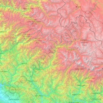
Name: Uttarkashi topographic map, elevation, terrain.
Location: Uttarkashi, India (30.47183 77.80955 31.45902 79.41725)
Average elevation: 11,099 ft
Minimum elevation: 1,631 ft
Maximum elevation: 23,314 ft
Other topographic maps
Click on a map to view its topography, its elevation and its terrain.
3d
India > Rajasthan > Ganganagar Tehsil > 1 LNP
3d, 1 LNP, Ganganagar Tehsil, Sri Ganganagar District, Rajasthan, India
Average elevation: 584 ft
Rohru
Rohru, Shimla District, Himachal Pradesh, 171207, India
Average elevation: 7,474 ft
Patan
India > Maharashtra > Patan
Patan, Satara District, Maharashtra, 415206, India
Average elevation: 2,192 ft
Dhupguri
Dhupguri, Jalpaiguri District, West Bengal, India
Average elevation: 466 ft
Haripad
India > Kerala > Karthikappally
Haripad, Karthikappally, Alappuzha District, Kerala, 690514, India
Average elevation: 13 ft
Sheoganj
India > Rajasthan > Sheoganj Tehsil
Sheoganj, Sheoganj Tehsil, Sirohi District, Rajasthan, 306902, India
Average elevation: 889 ft
Pokaran
India > Rajasthan > Pokaran Tehsil
Pokaran, Pokaran Tehsil, Jaisalmer District, Rajasthan, India
Average elevation: 751 ft
Kuther
India > Jammu and Kashmir > Shangus tehsil
Kuther, Shangus tehsil, Anantnag District, Jammu and Kashmir, 192201, India
Average elevation: 6,109 ft
Awantipora
Awantipora, Pulwama District, Jammu and Kashmir, India
Average elevation: 5,463 ft
Singahalli
India > Karnataka > Kolar taluk
Singahalli, Kolar taluk, Kolar District, Karnataka, India
Average elevation: 2,799 ft
Delwara
India > Madhya Pradesh > Tyonda Tahsil
Delwara, Tyonda Tahsil, Vidisha District, Madhya Pradesh, India
Average elevation: 1,398 ft
Dehradun
India > Uttarakhand > Dehradun
Dehradun, Dehradun District, Uttarakhand, 248001, India
Average elevation: 2,966 ft
Elimukku
India > Kerala > Kozhencherry
Elimukku, Kozhencherry, Pathanamthitta District, Kerala, 689504, India
Average elevation: 95 ft
Panner Jageer
India > Jammu and Kashmir > Tral
Panner Jageer, Tral, Pulwama District, Jammu and Kashmir, India
Average elevation: 6,631 ft
Tral
Tral, Pulwama District, Jammu and Kashmir, 192123, India
Average elevation: 8,294 ft
Malappuram
Malappuram, Ernad, Malappuram District, Kerala, India
Average elevation: 184 ft
Sreekandapuram
India > Kerala > Taliparamba
Sreekandapuram, Taliparamba, Kannur District, Kerala, 670631, India
Average elevation: 230 ft
Taiba
India > Jharkhand > Erki(Tamar II)
Taiba, Erki(Tamar II), Khunti District, Jharkhand, India
Average elevation: 1,850 ft
Kulana
India > Punjab > Budhlada Tahsil
Kulana, Budhlada Tahsil, Mansa District, Punjab, India
Average elevation: 725 ft
Surat
India > Gujarat > Katargam Taluka
Surat, Katargam Taluka, Surat District, Gujarat, 395008, India
Average elevation: 43 ft
Ameenpur mandal
Ameenpur mandal, Sangareddy District, Telangana, India
Average elevation: 1,811 ft
Duldula
India > Chhattisgarh > Duldula Tahsil
Duldula, Duldula Tahsil, Jashpur District, Chhattisgarh, 496334, India
Average elevation: 1,739 ft
Hukkeri
India > Karnataka > Hukkeri taluk
Hukkeri, Hukkeri taluk, Karnataka, 591309, India
Average elevation: 2,162 ft
Patauda
India > Madhya Pradesh > Unchahara Tahsil
Patauda, Unchahara Tahsil, Satna District, Madhya Pradesh, India
Average elevation: 1,106 ft
Sector 37D
India > Haryana > Gurugram District
Sector 37D, Gurgaon, Gurugram District, Haryana, India
Average elevation: 712 ft
Nakrekal
India > Telangana > Nakrekal mandal
Nakrekal, Nakrekal mandal, Nalgonda District, Telangana, 508211, India
Average elevation: 679 ft
Manjavadi
India > Tamil Nadu > Kilvelur > Anaimangalam
Manjavadi, Anaimangalam, Kilvelur, Nagapattinam District, Tamil Nadu, 611104, India
Average elevation: 16 ft
Jodhpur
India > Rajasthan > Jodhpur Tehsil
Jodhpur, Jodhpur Tehsil, Jodhpur District, Rajasthan, India
Average elevation: 781 ft
Lal Kuan
India > Uttar Pradesh > Ghaziabad
Lal Kuan, Ghaziabad, Ghaziabad District, Uttar Pradesh, 201016, India
Average elevation: 692 ft
Chandupatla
India > Telangana > Maddirala mandal
Chandupatla, Maddirala mandal, Suryapet District, Telangana, India
Average elevation: 633 ft
Sengipatti
India > Tamil Nadu > Thanjavur
Sengipatti, Thanjavur, Thanjavur District, Tamil Nadu, India
Average elevation: 259 ft
Simandhar Tenements & Flats
India > Gujarat > Mahesana Taluka
Simandhar Tenements & Flats, Mahesana Taluka, Mahesana District, Gujarat, 384001, India
Average elevation: 285 ft
Ramchandrapuram
India > Andhra Pradesh > A.Konduru
Ramchandrapuram, A.Konduru, NTR, Andhra Pradesh, India
Average elevation: 322 ft
Indian subcontinent
India > Maharashtra > Arni
Indian subcontinent, Arni, Yavatmal, Maharashtra, India
Average elevation: 1,155 ft
Kadungalloor
India > Kerala > Paravur > Edayar
Kadungalloor, Edayar, Paravur, Ernakulam District, Kerala, India
Average elevation: 26 ft
Shast
India > Himachal Pradesh > Kotkhai
Shast, Kotkhai, Shimla District, Himachal Pradesh, 171204, India
Average elevation: 7,516 ft
Haraluru
India > Karnataka > Tumkur taluk
Haraluru, Tumkur taluk, Tumakuru District, Karnataka, India
Average elevation: 2,835 ft
Shivpuri District
Shivpuri District, Madhya Pradesh, India
Average elevation: 1,184 ft
Gairan Wasti
India > Maharashtra > Dharashiv > Waruda
Gairan Wasti, Waruda, Dharashiv, Dharashiv District, Maharashtra, India
Average elevation: 2,175 ft
Boroonda
India > Rajasthan > Pipar City Tehsil
Boroonda, Pipar City Tehsil, Jodhpur(Rural) District, Rajasthan, India
Average elevation: 1,004 ft
Gubbalala
India > Karnataka > Bangalore South
Gubbalala, Bangalore South, Bengaluru Urban, Karnataka, 560062, India
Average elevation: 2,871 ft