Geolocate

Tatums topographic map

Click on the map to display elevation.

About this map

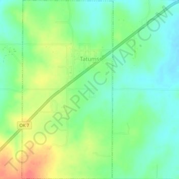
Name: Tatums topographic map, elevation, terrain.

Location: Tatums, Carter County, Oklahoma, 73487, United States (34.46337 -97.47500 34.49234 -97.45704)

Average elevation: 974 ft

Minimum elevation: 906 ft

Maximum elevation: 1,083 ft

Carter County trails, hiking, mountain biking, running and outdoor activities

Other topographic maps

Click on a map to view its topography, its elevation and its terrain.

Graham

United States > Oklahoma > Carter County

Average elevation: 942 ft

Tussy

United States > Oklahoma > Carter County

Average elevation: 974 ft

Fox

United States > Oklahoma > Carter County

Average elevation: 981 ft

Milo

United States > Oklahoma > Carter County

Average elevation: 906 ft

Pooleville

United States > Oklahoma > Carter County

Average elevation: 1,043 ft

Gear up for your next adventure:

👓Polarized Sunglasses - Outdoor sunglasses for glare reduction
🧴Hand Sanitizer - Keep hands clean while hiking
🧺Microfiber Travel Towels - Compact and fast-drying towels for trail use
🛶Inflatable Kayak - Portable kayak for rivers, lakes, and expeditions
😴Insulated Sleeping Pads - Compact and warm pads for high-elevation camping

As an Amazon Associate, this site earns from qualifying purchases at no extra cost to you.