
Make a donation
Gear up for your next adventure:
As an Amazon Associate, this site earns from qualifying purchases at no extra cost to you.
Tamiahua topographic map
Click on the map to display elevation.
Make a donation
Gear up for your next adventure:
As an Amazon Associate, this site earns from qualifying purchases at no extra cost to you.
About this map
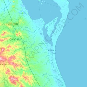
Name: Tamiahua topographic map, elevation, terrain.
Location: Tamiahua, Veracruz, 92560, Mexico (21.05677 -97.69237 21.58263 -97.22205)
Average elevation: 118 ft
Minimum elevation: -7 ft
Maximum elevation: 1,234 ft
Make a donation
Gear up for your next adventure:
As an Amazon Associate, this site earns from qualifying purchases at no extra cost to you.
Other topographic maps
Click on a map to view its topography, its elevation and its terrain.
Isthmus of Tehuantepec
At its narrowest point, the isthmus is 200 km (124 mi) across from gulf to gulf, or 192 km (119 mi) to the head of Laguna Superior on the Pacific coast. The Sierra Madre del Sur mountain range breaks down at this point into a broad, plateau-like ridge, whose elevation, at the highest point reached by the…
Average elevation: 909 ft
Veracruz City
Mexico > Veracruz > Municipio de Veracruz
As the municipal seat, the city of Veracruz is the governing authority for 128 other named localities during the 2010 census, forming a municipality with a territory of 241 km2 (93 sq mi). The population of the municipality is 552,156 inhabitants, of whom 428,323 or approximately 77.6% live in municipality's…
Average elevation: 33 ft
Make a donation
Gear up for your next adventure:
As an Amazon Associate, this site earns from qualifying purchases at no extra cost to you.
Córdoba
Córdoba is located in the center of the state of Veracruz, at 18º51'30" north latitude and 96º55'51" west longitude. It lies between the hills of Matlaquiahitl and Tepixtepec, at an elevation of 817 meters (2,680 feet) above mean sea level.
Average elevation: 3,379 ft
Make a donation
Gear up for your next adventure:
As an Amazon Associate, this site earns from qualifying purchases at no extra cost to you.
Cofre de Perote
Cofre de Perote, also known by its Nahuatl names Naupa-Tecutépetl (from Nāuhpa-Tēuctēpetl) and Nauhcampatépetl, both meaning something like "Place of Four Mountains" or "Mountain of the Lord of Four Places", is an inactive volcano located in the Mexican state of Veracruz, at the point where the…
Average elevation: 12,523 ft
Make a donation
Gear up for your next adventure:
As an Amazon Associate, this site earns from qualifying purchases at no extra cost to you.
Make a donation
Gear up for your next adventure:
As an Amazon Associate, this site earns from qualifying purchases at no extra cost to you.
Make a donation
Gear up for your next adventure:
As an Amazon Associate, this site earns from qualifying purchases at no extra cost to you.
Make a donation
Gear up for your next adventure:
As an Amazon Associate, this site earns from qualifying purchases at no extra cost to you.
Fraccionamiento Santa Regina
Mexico > Veracruz > Poza Rica de Hidalgo > Poza Rica
Average elevation: 233 ft
Make a donation
Gear up for your next adventure:
As an Amazon Associate, this site earns from qualifying purchases at no extra cost to you.
Make a donation
Gear up for your next adventure:
As an Amazon Associate, this site earns from qualifying purchases at no extra cost to you.
Make a donation
Gear up for your next adventure:
As an Amazon Associate, this site earns from qualifying purchases at no extra cost to you.
Fraccionamiento Costa Dorada
Mexico > Veracruz > Veracruz > Colonia del Proletariado (Pica Pica) > Fraccionamiento Costa Dorada
Average elevation: 85 ft
Make a donation
Gear up for your next adventure:
As an Amazon Associate, this site earns from qualifying purchases at no extra cost to you.