
Make a donation
Gear up for your next adventure:
As an Amazon Associate, this site earns from qualifying purchases at no extra cost to you.
Antofagasta Region topographic map
Click on the map to display elevation.
Make a donation
Gear up for your next adventure:
As an Amazon Associate, this site earns from qualifying purchases at no extra cost to you.
About this map
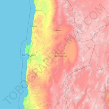
Name: Antofagasta Region topographic map, elevation, terrain.
Location: Antofagasta Region, Chile (-26.06110 -70.73714 -20.93439 -66.99052)
Average elevation: 7,746 ft
Minimum elevation: 0 ft
Maximum elevation: 21,119 ft
Make a donation
Gear up for your next adventure:
As an Amazon Associate, this site earns from qualifying purchases at no extra cost to you.
Other topographic maps
Click on a map to view its topography, its elevation and its terrain.
Santiago
Chile > Santiago Metropolitan Region > Provincia de Santiago
The city lies in the center of the Santiago Basin, a large bowl-shaped valley consisting of broad and fertile lands surrounded by mountains. The city has a varying elevation, gradually increasing from 400 m (1,312 ft) in the western areas to more than 700 m (2,297 ft) in the eastern areas. Santiago's…
Average elevation: 2,369 ft
Bahía Inglesa
Chile > Atacama Region > Provincia de Copiapó > Caldera
Bahia Inglesa ("English Bay") is a locality located near the port of Caldera in Atacama Region, Chile. It is situated at an average elevation of 10 meters above the sea level. As of 2017, it had a population of 535.
Average elevation: 33 ft
Atacama Desert
Chile > Antofagasta Region > Provincia de Antofagasta > Antofagasta
The Coastal Cliff of northern Chile west of the Chilean Coast Range is the main topographical feature of the coast. The geomorphology of the Atacama Desert has been characterized as a low-relief bench "similar to a giant uplifted terrace" by Armijo and co-workers. The intermediate depression (or Central…
Average elevation: 6,434 ft
Santiago
Chile > Santiago Metropolitan Region > Provincia de Santiago
The city lies in the center of the Santiago Basin, a large bowl-shaped valley consisting of broad and fertile lands surrounded by mountains. The city has a varying elevation, gradually increasing from 400 m (1,312 ft) in the western areas to more than 700 m (2,297 ft) in the eastern areas. Santiago's…
Average elevation: 2,375 ft
Make a donation
Gear up for your next adventure:
As an Amazon Associate, this site earns from qualifying purchases at no extra cost to you.
San José de La Mariquina
Chile > Los Ríos > Provincia de Valdivia > Mariquina
Average elevation: 105 ft
Nevado Tres Cruces
Chile > Atacama Region > Provincia de Copiapó > Copiapó
Average elevation: 20,459 ft
Make a donation
Gear up for your next adventure:
As an Amazon Associate, this site earns from qualifying purchases at no extra cost to you.
Cerro Torre
Chile > Magallanes and Chilean Antarctica Region > Provincia de Última Esperanza > Puerto Natales
Average elevation: 6,286 ft
Zona Austral
Chile > Region of Magallanes and Chilean Antarctica > Provincia de Última Esperanza > Puerto Natales
In the far south (Chile Austral), which extends from Valdivia through the Chacao Channel to Cape Horn, the Andes and the South Pacific meet. This district of the country is mountainous, heavily forested and inhospitable. The deeply indented coastline is filled with islands which preserve the general outline of…
Average elevation: 2,520 ft
Canal de Relave Codelco División El Teniente
Chile > Provincia de Cachapoal > Requínoa
Average elevation: 2,064 ft
Make a donation
Gear up for your next adventure:
As an Amazon Associate, this site earns from qualifying purchases at no extra cost to you.
Carretera Austral
Chile > Aysen del General Carlos Ibanez del Campo Region > Provincia de General Carrera > Río Ibáñez
Average elevation: 1,358 ft
Ojos del Salado
Chile > Atacama Region > Provincia de Copiapó > Copiapó
Nevado Ojos del Salado is a dormant complex volcano in the Andes on the Argentina–Chile border. It is the highest volcano on Earth and the highest peak in Chile. The upper reaches of Ojos del Salado consist of several overlapping lava domes, lava flows and volcanic craters, with sparse ice cover. The complex…
Average elevation: 21,148 ft
Isla Carmen
Chile > Aysen del General Carlos Ibanez del Campo Region > Provincia de Aysén > Puerto Aysén
Average elevation: 72 ft
Make a donation
Gear up for your next adventure:
As an Amazon Associate, this site earns from qualifying purchases at no extra cost to you.
Humedal Desembocadura del Río Copiapó
Chile > Atacama Region > Provincia de Copiapó > Caldera
Average elevation: 102 ft
Yendegaia
Chile > Magallanes and Chilean Antarctica Region > Provincia de la Antártica Chilena > Cape Horn
Average elevation: 299 ft
Make a donation
Gear up for your next adventure:
As an Amazon Associate, this site earns from qualifying purchases at no extra cost to you.
Santiago
Chile > Santiago Metropolitan Region > Provincia de Santiago
The city lies in the center of the Santiago Basin, a large bowl-shaped valley consisting of broad and fertile lands surrounded by mountains. The city has a varying elevation, gradually increasing from 400 meters (1,300 feet) in the western areas to more than 700 m (2,297 ft) in the eastern areas. Santiago's…
Average elevation: 2,369 ft
Ma'uŋa Te Hoŋa (O Koro)
Chile > Valparaiso Region > Easter Island Province > Easter Island
Average elevation: 837 ft
Make a donation
Gear up for your next adventure:
As an Amazon Associate, this site earns from qualifying purchases at no extra cost to you.
Santiago
Chile > Santiago Metropolitan Region > Provincia de Santiago
The city lies in the center of the Santiago Basin, a large bowl-shaped valley consisting of broad and fertile lands surrounded by mountains. The city has a varying elevation, gradually increasing from 400 m (1,312 ft) in the western areas to more than 700 m (2,297 ft) in the eastern areas. Santiago's…
Average elevation: 2,375 ft
Volcán Llullaillaco
Chile > Antofagasta Region > Provincia de Antofagasta > Antofagasta
Llullaillaco (Spanish: [ʎuʎajˈʎako], Latin American Spanish: [ɟʝuʝajˈʝako]) is a dormant stratovolcano on the border between Argentina (Salta Province) and Chile (Antofagasta Region). It is part of the Llullaillaco National Park and lies in the Puna de Atacama, a region of tall volcanic peaks on a…
Average elevation: 20,299 ft
Make a donation
Gear up for your next adventure:
As an Amazon Associate, this site earns from qualifying purchases at no extra cost to you.
Puerto Natales
Chile > Magallanes and Chilean Antarctica Region > Provincia de Última Esperanza
Average elevation: 463 ft
Puerto Guadal
Chile > Aysen del General Carlos Ibanez del Campo Region > Provincia de General Carrera > Chile Chico
Average elevation: 1,138 ft
Camar
Chile > Antofagasta Region > Provincia de El Loa > San Pedro de Atacama
Average elevation: 8,930 ft
Mirador Cóndor
Chile > Magallanes and Chilean Antarctica Region > Provincia de Última Esperanza > Torres del Paine
Average elevation: 459 ft
Make a donation
Gear up for your next adventure:
As an Amazon Associate, this site earns from qualifying purchases at no extra cost to you.
Santa Rita Sur
Chile > Santiago Metropolitan Region > Provincia de Cordillera
Average elevation: 2,493 ft
Cerro Torre
Chile > Magallanes and Chilean Antarctica Region > Provincia de Última Esperanza
Average elevation: 6,286 ft
Laguna Santa Rosa
Chile > Atacama Region > Provincia de Copiapó > Copiapó
Average elevation: 12,431 ft
Make a donation
Gear up for your next adventure:
As an Amazon Associate, this site earns from qualifying purchases at no extra cost to you.
El Peumo
Chile > Santiago Metropolitan Region > Provincia de Talagante > Talagante
Average elevation: 1,063 ft
Santiago
Chile > Santiago Metropolitan Region > Provincia de Santiago
The city lies in the center of the Santiago Basin, a large bowl-shaped valley consisting of broad and fertile lands surrounded by mountains. The city has a varying elevation, gradually increasing from 400 m (1,312 ft) in the western areas to more than 700 m (2,297 ft) in the eastern areas. Santiago's…
Average elevation: 2,375 ft
Cerro El Monstruo
Chile > Los Lagos Region > Provincia de Llanquihue > Cochamó
Average elevation: 4,252 ft
Make a donation
Gear up for your next adventure:
As an Amazon Associate, this site earns from qualifying purchases at no extra cost to you.
Socaire
Chile > Antofagasta Region > Provincia de El Loa > San Pedro de Atacama
Average elevation: 10,797 ft
Chacarillas
Chile > Valparaiso Region > Provincia de San Antonio > Cartagena
Average elevation: 1,217 ft
Make a donation
Gear up for your next adventure:
As an Amazon Associate, this site earns from qualifying purchases at no extra cost to you.
Make a donation
Gear up for your next adventure:
As an Amazon Associate, this site earns from qualifying purchases at no extra cost to you.
Valle del Aconcagua
Chile > Valparaiso Region > Provincia de Quillota > Hijuelas > La Sombra
Average elevation: 1,145 ft
Atacama Desert
Chile > Antofagasta Region > Provincia de Antofagasta > Antofagasta
The Coastal Cliff of northern Chile west of the Chilean Coast Range is the main topographical feature of the coast. The geomorphology of the Atacama Desert has been characterized as a low-relief bench "similar to a giant uplifted terrace" by Armijo and co-workers. The intermediate depression (or Central…
Average elevation: 6,434 ft
El Cobre
Chile > Valparaiso Region > Provincia de San Felipe de Aconcagua > Catemu
Average elevation: 1,795 ft
Laguna Lejía
Chile > Antofagasta Region > Provincia de El Loa > San Pedro de Atacama
Lejía Lake is a circular, shallow lake at an elevation of 4,325 metres (14,190 ft) with a surface area of 1.9 square kilometres (0.73 sq mi) or 2 square kilometres (0.77 sq mi). It is a polymictic lake which freezes over occasionally and whose waters are turned over quickly, mainly through evaporation. Winds…
Average elevation: 14,242 ft
Make a donation
Gear up for your next adventure:
As an Amazon Associate, this site earns from qualifying purchases at no extra cost to you.
Clear water
Chile > Aysen del General Carlos Ibanez del Campo Region > Provincia de Capitán Prat > O’Higgins
Average elevation: 1,309 ft
A018
Chile > Antofagasta Region > Provincia de El Loa > San Pedro de Atacama > Atacama Large Millimeter/submillimeter Array
Average elevation: 16,473 ft
Hanga Roa
Chile > Valparaiso Region > Easter Island Province > Easter Island
Average elevation: 194 ft
Volcán Ojos del Toro
Chile > Antofagasta Region > Provincia de El Loa > San Pedro de Atacama
Average elevation: 18,054 ft
Make a donation
Gear up for your next adventure:
As an Amazon Associate, this site earns from qualifying purchases at no extra cost to you.
Isla Florencia
Chile > Aysen del General Carlos Ibanez del Campo Region > Provincia de Aysén > Cisnes
Average elevation: 43 ft
Make a donation
Gear up for your next adventure:
As an Amazon Associate, this site earns from qualifying purchases at no extra cost to you.
Tupungato
Chile > Santiago Metropolitan Region > Provincia de Cordillera > San José de Maipo
Average elevation: 19,692 ft
El Barrancón Norte
Chile > Santiago Metropolitan Region > Provincia de Maipo
Average elevation: 1,873 ft
Placilla de Peñuelas
Chile > Valparaiso Region > Provincia de Valparaíso > Valparaíso
Average elevation: 1,161 ft
Make a donation
Gear up for your next adventure:
As an Amazon Associate, this site earns from qualifying purchases at no extra cost to you.
Tupungato
Chile > Santiago Metropolitan Region > Provincia de Cordillera > San José de Maipo
Average elevation: 19,692 ft
Parque Titanium
Chile > Santiago Metropolitan Region > Provincia de Santiago
Average elevation: 2,113 ft
Parque Industrial Los Libertadores
Chile > Santiago Metropolitan Region > Provincia de Chacabuco > Colina
Average elevation: 1,706 ft
Make a donation
Gear up for your next adventure:
As an Amazon Associate, this site earns from qualifying purchases at no extra cost to you.
Make a donation
Gear up for your next adventure:
As an Amazon Associate, this site earns from qualifying purchases at no extra cost to you.
Puyuhuapi
Chile > Aysen del General Carlos Ibanez del Campo Region > Provincia de Aysén > Cisnes
Average elevation: 751 ft
San Alfonso
Chile > Santiago Metropolitan Region > Provincia de Cordillera > San José de Maipo
Average elevation: 4,501 ft
Punta Pite
Chile > Valparaiso Region > Provincia de Petorca > Zapallar > Punta Pite Norte
Average elevation: 115 ft
Make a donation
Gear up for your next adventure:
As an Amazon Associate, this site earns from qualifying purchases at no extra cost to you.
El Molino Viejo
Chile > O'Higgins Region > Provincia de Cachapoal > Requínoa > Pichiguao
Average elevation: 1,224 ft
Isla Florencia
Chile > Aysen del General Carlos Ibanez del Campo Region > Provincia de Aysén > Cisnes
Average elevation: 43 ft
Make a donation
Gear up for your next adventure:
As an Amazon Associate, this site earns from qualifying purchases at no extra cost to you.
Tronador
Chile > Los Lagos Region > Provincia de Llanquihue > Puerto Varas
Tronador (Spanish: Cerro Tronador) is an extinct stratovolcano in the southern Andes, located along the border between Argentina and Chile, near the Argentine city of Bariloche. The mountain was named Tronador (Spanish for "Thunderer") by locals in reference to the sound of falling seracs. With an altitude of…
Average elevation: 9,304 ft
Make a donation
Gear up for your next adventure:
As an Amazon Associate, this site earns from qualifying purchases at no extra cost to you.
Norte Grande
Chile > Antofagasta Region > Provincia de Antofagasta > Sierra Gorda
The desert region is an elevated arid plateau descending gradually from the Andes towards the coast, where it breaks down abruptly from elevations of 800 to 1500 ft. From the sea this plateau escarpment has the appearance of a range of flat topped hills closely following the coast line. This topography…
Average elevation: 6,929 ft
La Chupalla
Chile > Valparaiso Region > Provincia de San Felipe de Aconcagua > Llay-Llay
Average elevation: 2,789 ft
Caleta Camarones
Chile > Arica y Parinacota Region > Provincia de Arica > Camarones
Average elevation: 617 ft
Cerro Penitentes
Chile > Santiago Metropolitan Region > Provincia de Cordillera > San José de Maipo
Average elevation: 12,195 ft
Make a donation
Gear up for your next adventure:
As an Amazon Associate, this site earns from qualifying purchases at no extra cost to you.
Peteroa
Chile > Maule Region > Provincia de Curicó > Sagrada Familia > Santa Ana
Average elevation: 456 ft
Agua de la Gloria
Chile > Biobío Region > Provincia de Concepción > Concepcion > El Pino
Average elevation: 308 ft
Atacama Desert
Chile > Antofagasta Region > Provincia de Antofagasta > Antofagasta
The Coastal Cliff of northern Chile west of the Chilean Coast Range is the main topographical feature of the coast. The geomorphology of the Atacama Desert has been characterized as a low-relief bench "similar to a giant uplifted terrace" by Armijo and co-workers. The intermediate depression (or Central…
Average elevation: 6,434 ft
Make a donation
Gear up for your next adventure:
As an Amazon Associate, this site earns from qualifying purchases at no extra cost to you.
Cerro Alvarado
Chile > Santiago Metropolitan Region > Provincia de Cordillera > San José de Maipo
Average elevation: 12,917 ft
Make a donation
Gear up for your next adventure:
As an Amazon Associate, this site earns from qualifying purchases at no extra cost to you.
Mendoza
Chile > Arica y Parinacota Region > Provincia de Parinacota > Putre
Average elevation: 11,949 ft
Condominio San José
Chile > O'Higgins Region > Provincia de Cachapoal > Requínoa
Average elevation: 1,378 ft
Make a donation
Gear up for your next adventure:
As an Amazon Associate, this site earns from qualifying purchases at no extra cost to you.