Geolocate

Alassio topographic map

Click on the map to display elevation.

About this map

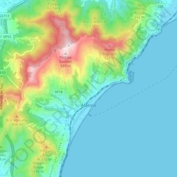
Name: Alassio topographic map, elevation, terrain.

Location: Alassio, Savona, Liguria, 17021, Italy (43.98968 8.12398 44.03782 8.20853)

Average elevation: 459 ft

Minimum elevation: -3 ft

Maximum elevation: 1,926 ft

Other topographic maps

Click on a map to view its topography, its elevation and its terrain.

Vara Superiore

Italy > Liguria > Savona

Average elevation: 2,687 ft

Perru

Italy > Liguria > Savona > Albisola Superiore

Average elevation: 1,207 ft

Montefreddo

Italy > Liguria > Savona > Mallare

Average elevation: 1,726 ft

Praie

Italy > Liguria > Savona > Piana Crixia

Average elevation: 1,125 ft

San Giuseppe di Cairo

Italy > Liguria > Savona > Cairo Montenotte

Average elevation: 1,293 ft

Riofreddo

Italy > Liguria > Savona

Average elevation: 2,677 ft

Santa Giulia

Italy > Liguria > Savona > Dego

Average elevation: 1,804 ft

Armati

Italy > Liguria > Savona > Stellanello

Average elevation: 1,401 ft

Villarelli

Italy > Liguria > Savona > Stellanello

Average elevation: 1,102 ft

Varigotti

Italy > Liguria > Savona > Finale Ligure

Average elevation: 328 ft

Bardino Nuovo

Italy > Liguria > Savona

Average elevation: 935 ft

Costa dei Ginestri

Italy > Liguria > Savona > Bergeggi

Average elevation: 266 ft

Varigotti

Italy > Liguria > Savona > Finale Ligure

Average elevation: 328 ft

Monte Agri

Italy > Liguria > Savona > Savona

Average elevation: 1,037 ft

Gear up for your next adventure:

🔭Stargazing Telescopes - Perfect for camping in low-light pollution areas shown on maps
🥾Men's Hiking Boots - Durable, waterproof footwear for rugged terrain and steep inclines
🧺Microfiber Travel Towels - Compact and fast-drying towels for trail use
🥤Water Filter Bottle - All‑in‑one filter bottle for safe hydration
🗃️Trail First Aid Kit - Essential kit for outdoor injuries and emergencies

As an Amazon Associate, this site earns from qualifying purchases at no extra cost to you.