
Oba topographic map
Click on the map to display elevation.
About this map
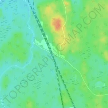
Name: Oba topographic map, elevation, terrain.
Average elevation: 1,086 ft
Minimum elevation: 1,047 ft
Maximum elevation: 1,171 ft
Other topographic maps
Click on a map to view its topography, its elevation and its terrain.
Limerick Lake
Canada > Ontario > Algoma District > Unorganized North Algoma
Average elevation: 1,657 ft
Kabinakagami Lake
Canada > Ontario > Algoma District > Unorganized North Algoma
Average elevation: 1,089 ft
Lucille Lake;Wood Creek
Canada > Ontario > Algoma District > Unorganized North Algoma
Average elevation: 1,447 ft
Moccasin Lake
Canada > Ontario > Algoma District > Unorganized North Algoma
Average elevation: 1,565 ft
Clayton Lake
Canada > Ontario > Algoma District > Unorganized North Algoma
Average elevation: 1,250 ft
Seymour Lake
Canada > Ontario > Algoma District > Unorganized North Algoma
Average elevation: 1,430 ft
Kirkpatrick Lake
Canada > Ontario > Algoma District > Unorganized North Algoma
Average elevation: 1,407 ft
Northland Lake
Canada > Ontario > Algoma District > Unorganized North Algoma
Average elevation: 1,270 ft
Manitowik Lake
Canada > Ontario > Algoma District > Unorganized North Algoma
Average elevation: 1,293 ft
Mosambik Lake
Canada > Ontario > Algoma District > Unorganized North Algoma
Average elevation: 1,191 ft
Goulais River
Canada > Ontario > Algoma District > Unorganized North Algoma
Average elevation: 1,188 ft
Kimiwan Creek;Kimiwan Lakes
Canada > Ontario > Algoma District > Unorganized North Algoma
Average elevation: 1,450 ft
Montreal River
Canada > Ontario > Algoma District > Unorganized North Algoma
Average elevation: 1,181 ft
Mashagama Lake
Canada > Ontario > Algoma District > Unorganized North Algoma
Average elevation: 1,503 ft
Montreal Island
Canada > Ontario > Algoma District > Unorganized North Algoma
Average elevation: 623 ft
Kabinakagamisis Lake
Canada > Ontario > Algoma District > Unorganized North Algoma
Average elevation: 1,063 ft
Chapleau River
Canada > Ontario > Algoma District > Unorganized North Algoma
Average elevation: 1,076 ft
Wakomata Lake
Canada > Ontario > Algoma District > Unorganized North Algoma
Average elevation: 1,247 ft