Geolocate

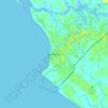
Rivercess County topographic map

Click on the map to display elevation.

About this map
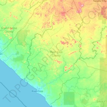
Name: Rivercess County topographic map, elevation, terrain.

Location: Rivercess County, Liberia (5.26783 -9.73356 6.49923 -9.05556)

Average elevation: 374 ft

Minimum elevation: -7 ft

Maximum elevation: 1,850 ft

Other topographic maps

Click on a map to view its topography, its elevation and its terrain.
Buchanan

Liberia > Grand Bassa County > Commonwealth-B

Average elevation: 10 ft

Grimes Farm

Liberia > Montserrado County > Todee

Average elevation: 259 ft

Dorkorta

Liberia > Gbarpolu County > Gounwolaila

Average elevation: 633 ft

Palala

Liberia > Bong County > Yeallequelleh

Average elevation: 768 ft

Harris Farm

Liberia > Lofa County > Salayea

Average elevation: 1,024 ft

Kpeloe Ndama

Liberia > Lofa County > Kolahun > Foya

Average elevation: 1,457 ft

Underwear

Liberia > Gbarpolu County > Bopolu

Average elevation: 302 ft

Noway

Liberia > Grand Bassa County > St. John River City

Average elevation: 266 ft

S.G. Kollie

Liberia > Bong County > Suakoko

Average elevation: 837 ft

Wahington Village

Liberia > Bong County > Jorquelleh

Average elevation: 758 ft

Gear up for your next adventure:

🔦LED Headlamp - Bright and durable LED headlamp for night navigation
🔥Camping Stove - Portable stove for camping and backcountry cooking
🪶Paracord Bracelet - Survival bracelet with built‑in tools
🪑Portable Camp Table - Compact table for campsite meals
🛠️Backpacking Tool Kit - Essential toolkit for outdoor repairs

As an Amazon Associate, this site earns from qualifying purchases at no extra cost to you.