
Make a donation
Gear up for your next adventure:
As an Amazon Associate, this site earns from qualifying purchases at no extra cost to you.
Grosswangen topographic map
Click on the map to display elevation.
Make a donation
Gear up for your next adventure:
As an Amazon Associate, this site earns from qualifying purchases at no extra cost to you.
Grosswangen
Grosswangen liegt ca. 25 km nordwestlich von Luzern. Die Region um Grosswangen, Buttisholz und Ruswil wird auch, nach dem Bach Rot, Rottal genannt. Der höchste Punkt der Gemeinde ist die Oberhöhe mit 747 m ü. M., der tiefste nahe dem Naturlehrgebiet Buchwald auf 523 m ü. M.
Make a donation
Gear up for your next adventure:
As an Amazon Associate, this site earns from qualifying purchases at no extra cost to you.
About this map
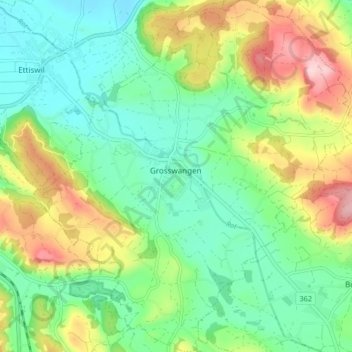
Name: Grosswangen topographic map, elevation, terrain.
Location: Grosswangen, Luzern, 6022, Schweiz (47.10316 8.01538 47.15957 8.09418)
Average elevation: 1,932 ft
Minimum elevation: 1,663 ft
Maximum elevation: 2,454 ft
Make a donation
Gear up for your next adventure:
As an Amazon Associate, this site earns from qualifying purchases at no extra cost to you.
Other topographic maps
Click on a map to view its topography, its elevation and its terrain.
Make a donation
Gear up for your next adventure:
As an Amazon Associate, this site earns from qualifying purchases at no extra cost to you.
Make a donation
Gear up for your next adventure:
As an Amazon Associate, this site earns from qualifying purchases at no extra cost to you.