Geolocate

Masbate topographic map

Click on the map to display elevation.

Masbate

The general surface configuration of the province ranges from slightly undulating to rolling and from hilly to mountainous. In each island, the rugged topography is concentrated in the northeastern portion and gradually recedes to blunt hills and rolling areas in the south, southeast, and southwest.

Wikipedia (CC-BY-SA 3.0)

About this map

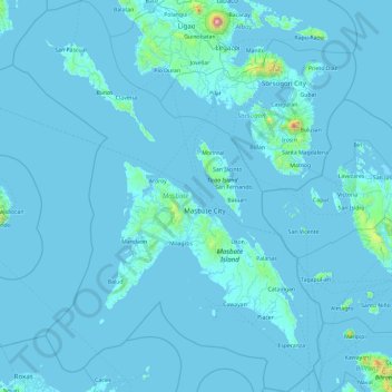
Name: Masbate topographic map, elevation, terrain.

Location: Masbate, Bicol Region, Philippines (11.51538 122.69879 13.35569 124.19422)

Average elevation: 92 ft

Minimum elevation: -7 ft

Maximum elevation: 7,523 ft

Other topographic maps

Click on a map to view its topography, its elevation and its terrain.

Quezon City

Philippines

Founded as a pueblo by Saint Pedro Bautista in 1590, San Francisco del Monte may be considered Quezon City's oldest district. The original land area of the old town of San Francisco del Monte was approximately2.5 square kilometres (1.0 sq mi) and covered parts of what is currently known as Project 7 and 8 and…

Average elevation: 187 ft

Rizal

Philippines

Average elevation: 312 ft

Malolos

Philippines > Bulacan

Malolos is relatively flat of about 0.81% to a gently sloping of 2.17%. The slope of the land descends towards west, southwest to southern direction. The highest land elevation is at about 6.0 meters above sea level while the lowest is only half a meter below sea level. A network of natural waterways and…

Average elevation: 20 ft

Butuan

Philippines

Average elevation: 377 ft

Legazpi

Philippines > Albay

Legazpi's topography is generally plain on the northeastern areas, with slopes ranging from five to fifteen degrees. The southern areas have mostly rolling to hilly terrain. In the city's coastal areas, the terrain varies from plain (north) to hilly (south). Legazpi is criss-crossed by several rivers including…

Average elevation: 492 ft

Lapu-Lapu

Philippines

Average elevation: 305 ft

Zamboanga City

Philippines > Zamboanga Peninsula > Zamboanga City

The overall topography of the city could be described as rolling to very steep. There are some flat lands, mostly narrow strips along the east coast. The urban center is mostly flat with a gentle slope to the interior, ranging from 0 to 3%. The highest registered elevation is 1,200 metres. In terms of slope, a…

Average elevation: 272 ft

Cabadbaran

Philippines > Agusan del Norte

It is 29 kilometres (18 mi) from Butuan. It is generally flat with rolling hills and swamplands in its western part. The highest of all mountains in the Caraga region, Mount Hilong-Hilong (with an altitude of 2,012 metres (6,601 ft) above sea level), rises in this city.

Average elevation: 587 ft

Baguio

Philippines

In 1903, Filipinos, Japanese and Chinese workers were hired to build Kennon Road, the first road directly connecting Baguio with the lowlands of La Union and Pangasinan. Before this, the only road to Benguet was Naguilian Road, and it was largely a horse trail at higher elevations. Camp John Hay was…

Average elevation: 2,890 ft

Manuel Guianga

Philippines > Davao City

Average elevation: 1,729 ft

Sevilla

Philippines > Bohol

Average elevation: 512 ft

Meycauayan

Philippines > Bulacan

Average elevation: 89 ft

Bauang

Philippines > La Union

Average elevation: 131 ft

Tagbilaran

Philippines > Bohol

Average elevation: 115 ft

Bacolod

Philippines

Bacólod (English: Bacolod), is derived from bakólod (Old Spelling: bacólod), the Old Hiligaynon (Old Ilonggo) (Old Spelling: Ylongo and Ilongo) word for a "hill, turtle, mound, rise, hillock, down, any small eminence or elevation", since the resettlement was founded on a stony, hilly area, now the barangay…

Average elevation: 161 ft

Samar

Philippines

Average elevation: 125 ft

North Cotabato

Philippines > North Cotabato

Average elevation: 410 ft

San Miguel

Philippines > Bulacan

Average elevation: 72 ft

Aparri

Philippines > Cagayan

Average elevation: 3 ft

Sison

Philippines > Pangasinan

Average elevation: 407 ft

Dagupan

Philippines > Pangasinan

Average elevation: 39 ft

Marikina

Philippines

Average elevation: 262 ft

Taguig

Philippines

Average elevation: 128 ft

Pasig

Philippines

Average elevation: 151 ft

Daraga

Philippines > Albay

67.3% of the total municipal land area has a predominantly low elevation of up to 100 metres (330 ft). The surface terrain is generally characterized by combination of level to nearly level areas, gentle to undulating areas and undulating to rolling areas.

Average elevation: 249 ft

Cebu City

Philippines > Cebu > Cebu City

Average elevation: 459 ft

San Fernando

Philippines > Pampanga

Average elevation: 79 ft

Calumpang

Philippines > Bulacan > San Miguel

Average elevation: 135 ft

San Isidro

Philippines > Albay > Santo Domingo

Average elevation: 203 ft

Bulusan

Philippines > Sorsogon

Average elevation: 289 ft

Tamacan

Philippines > Cavite > Amadeo

Average elevation: 961 ft

Tua

Philippines > Cavite > Magallanes

Average elevation: 883 ft

Bakakeng Norte

Philippines

Average elevation: 4,524 ft

Nueva Vizcaya

Philippines

Average elevation: 351 ft

Mount Pinatubo

Philippines > Zambales

Even before the 1991 eruption, Mount Pinatubo had little topographic prominence: it was 1,745 m (5,725 ft) above sea level, only about 600 m (2,000 ft) above nearby plains, and only about 200 m (660 ft) higher than surrounding peaks, which largely obscured it from view. It is part of a chain of volcanoes which…

Average elevation: 3,435 ft

Alfonso

Philippines > Cavite > Alfonso

Average elevation: 1,355 ft

Mandaue

Philippines

It is one of the two (the other one being the municipality of Consolacion) local government units located within the mainland Metro Cebu where the elevation of land is less than 100 m (330 ft).

Average elevation: 358 ft

Tanay

Philippines > Rizal

Average elevation: 105 ft

Limay

Philippines > Bataan > Limay

Average elevation: 138 ft

Valencia

Philippines > Bukidnon

The city's topography is characterized as flat to undulating hills with extensive plateaus and mountainous areas and cliffs on both eastern and western portions bounding the municipality of San Fernando on the east and the municipality of Talakag on the west. Its highest point is Mount Kalatungan in the…

Average elevation: 1,857 ft

Janiuay

Philippines > Iloilo

Santo Tomas approximate population is 500–800. Santo Tomas (Pakol to locals) is bounded by Madong in the east, Mangil in the north-east and Danao in the south west. It is accessible by three class C feeder roads in the east, south-west and south-east. Agriculture centers around rice, corn, coffee, beans,…

Average elevation: 269 ft

Tagaytay

Philippines > Cavite

The southern and eastern portions of Tagaytay are covered by hills and mountains which is generally forests, pine trees and open grasslands. The city lies along Tagaytay Ridge, a ridge stretching about 32 kilometres (20 mi) from Mount Batulao in the west to Mount Sungay in the east with elevations averaging…

Average elevation: 751 ft

San Juan

Philippines

"San Juan" is a contraction of the city's traditional name of "San Juan del Monte" (lit. 'Saint John of the Mountain'). As with numerous other places in the Philippines, the name combines a patron saint and a toponym; in this case Saint John the Baptist with the locale's hilly terrain and relatively higher…

Average elevation: 115 ft

Sorsogon City

Philippines > Sorsogon

Sorsogon City covers a land area of 31,292 hectares (120.82 sq mi). It is at the southernmost tip of the Bicol Peninsula and of Luzon Island. The city is bounded by Castilla in the west, Manito in the northwest, Albay Gulf in the north, Prieto Diaz in the east, Gubat in the southeast, Casiguran in the…

Average elevation: 292 ft

Banisilan

Philippines > Cotabato

Average elevation: 1,286 ft

Concepcion

Philippines > Pampanga > Mexico

Average elevation: 46 ft

Maco

Philippines > Davao de Oro

Average elevation: 276 ft

Badian

Philippines > Cebu

Average elevation: 371 ft

Davao City

Philippines

Average elevation: 213 ft

Dau

Philippines > Pampanga

Average elevation: 328 ft

Naujan

Philippines > Oriental Mindoro

Average elevation: 13 ft

Parañaque

Philippines

Average elevation: 46 ft

Macasandig

Philippines

Average elevation: 138 ft

Batanes

Philippines

Average elevation: 85 ft

Zamboanga del Sur

Philippines

Average elevation: 387 ft

Romblon Island

Philippines > Romblon

Average elevation: 141 ft

Tublay

Philippines > Benguet

According to the Philippine Statistics Authority, the municipality has a land area of 102.55 square kilometres (39.59 sq mi)  constituting 3.70% of the 2,769.08-square-kilometre- (1,069.15 sq mi) total area of Benguet. The topography is generally mountainous with an elevation of 1,400 metres (4,600 ft) above…

Average elevation: 4,121 ft

Laoag

Philippines > Ilocos Norte > Brgy. 13

Average elevation: 157 ft

Carcar

Philippines > Cebu

The land is generally level with less than 18% slope comprising 78.7% of the total land area. Areas with slopes ranging from 18 to 50% cover 19.3% of the total land area and those over 50% slope comprise approximately 1.9%. The highest recorded elevation is a little over 660 metres (2,170 ft) above sea level,…

Average elevation: 318 ft

Santa Maria

Philippines > Bulacan

The topography of Santa Maria is generally flat, however, it is becoming hilly towards the north. This area covers the barangays of Silangan, Mag-asawang Sapa, Pulong Buhangin and some parts of Balasing with landscape ranging from 8 to 18 percent slope. The rest of the barangays have a slope range from level…

Average elevation: 59 ft

Trece Martires

Philippines > Cavite

The city of Trece Martires is characterised with ground elevation ranging from 30m to nearly 400m. Its ground slope ranges from 0.5 to 2%.

Average elevation: 492 ft

Talisay

Philippines > Cebu

Average elevation: 328 ft

Iligan

Philippines

Average elevation: 751 ft

Davao City

Philippines

Average elevation: 184 ft

Mauban

Philippines > Quezon

Average elevation: 141 ft

Calinog

Philippines > Iloilo

Average elevation: 246 ft

Amadeo

Philippines > Cavite > Amadeo

Average elevation: 1,385 ft

Norzagaray

Philippines > Bulacan

Average elevation: 217 ft

Dumaguete

Philippines > Negros Oriental > Dumaguete

As a coastal city, it is bounded on the east by the Bohol Sea and the Tañon Strait, serving as a natural border of southeastern Negros Island Region to the neighboring Central Visayas. The city's topography is generally flat from two to six kilometers from the shoreline. It slopes gently upwards to the…

Average elevation: 548 ft

Tagum

Philippines > Davao del Norte

One of the significant accomplishments of the officialdom of Tagum during the 1990s was its elevation from a second to the first-class municipality. This opened a gateway to increase its financial resources through the Internal Revenue Allocation (IRA) from the national government and local revenues. This was…

Average elevation: 338 ft

Patag Island

Philippines

Average elevation: 0 ft

Kota Island

Philippines

Average elevation: 0 ft

Lankiam Cay

Philippines

Average elevation: 0 ft

Estero de Vitas

Philippines > Manila

Average elevation: 16 ft

El Salvador

Philippines > Misamis Oriental

Average elevation: 230 ft

San Gabriel

Philippines > La Union

The Municipality of San Gabriel is recognized as the largest municipality by land area in La Union. The town’s topography is predominantly mountainous, gradually ascending eastward, with a mix of scrubland, grassland, and wetland ecosystems. Its landscape is traversed by the Baroro River, the town's major…

Average elevation: 430 ft

Guadalupe

Philippines > Cebu

Average elevation: 200 ft

Davao Gulf

Philippines

Average elevation: 0 ft

Cainta

Philippines > Rizal

Average elevation: 79 ft

Tabuelan

Philippines > Cebu

Average elevation: 148 ft

Mount Halcon

Philippines > Oriental Mindoro

Mount Halcon (Filipino: Bundok Halcon) and (Spanish: Monte Halcón) is the highest mountain in Mindoro. According to the new data released by Oriental Mindoro peakvisor as of 2022, it has an elevation of 2,616 metres (8,583 ft) above sea level, higher than the previous estimates of 2,586 m (8,484 ft) although…

Average elevation: 6,959 ft

Lawak Island

Philippines

Average elevation: 0 ft

Philex Mines

Philippines > Benguet

Average elevation: 4,019 ft

Badoc

Philippines > Ilocos Norte

The celebrated Philippine painter Juan Luna was baptized in Badoc Church on 27 October 1857. At present, the church houses the miraculous statue of the Blessed Virgin Mary venerated under the title Virgin of Miracles, crowned by Catholic bishops in 1980, and was granted a Canonical coronation by Pope Francis…

Average elevation: 66 ft

Surigao del Sur

Philippines

Average elevation: 899 ft

Candaba

Philippines

Average elevation: 20 ft

Kinatihan II

Philippines

Average elevation: 72 ft

Ibabang Bukal

Philippines

Average elevation: 833 ft

Cabatang

Philippines

Average elevation: 1,099 ft

Pinget

Philippines

Average elevation: 4,692 ft

Caloocan

Philippines

Average elevation: 266 ft

Aurora Hill North Central

Philippines

Average elevation: 4,852 ft

Baracatan

Philippines

Average elevation: 1,171 ft

Besigan

Philippines

Average elevation: 1,916 ft

Talomo River

Philippines

Average elevation: 659 ft

Asin

Philippines

Average elevation: 4,334 ft

Catambungan

Philippines

Average elevation: 16 ft

Tablas Strait

Philippines

Average elevation: 0 ft

Buenavista

Philippines

Average elevation: 367 ft

Poliwes

Philippines

Average elevation: 4,583 ft

Gear up for your next adventure:

🎒Waterproof Dry Bags - Keep your electronics and maps dry inside your pack
🩳Quick‑Dry Hiking Shorts - Comfortable and quick‑dry shorts for summer hiking
🧭Orienteering Set - Complete compass and map reading kit
🚁Photography Drones - Capture stunning aerial views of landforms and topography
🧦Hiking Socks - Comfortable socks to prevent blisters on long hikes

As an Amazon Associate, this site earns from qualifying purchases at no extra cost to you.