
Manchaca topographic map
Click on the map to display elevation.
About this map
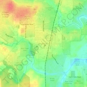
Name: Manchaca topographic map, elevation, terrain.
Location: Manchaca, Travis County, Texas, 78652, United States (30.12077 -97.85306 30.16077 -97.81306)
Average elevation: 682 ft
Minimum elevation: 591 ft
Maximum elevation: 791 ft
Travis County trails, hiking, mountain biking, running and outdoor activities
Other topographic maps
Click on a map to view its topography, its elevation and its terrain.
Mary Moore Searight zMetropolitan Park
United States > Texas > Travis County > Austin
Average elevation: 659 ft
Walnut Creek Metropolitan Park
United States > Texas > Travis County > Austin
Average elevation: 702 ft