
Make a donation
Gear up for your next adventure:
As an Amazon Associate, this site earns from qualifying purchases at no extra cost to you.
Pineville topographic map
Click on the map to display elevation.
Make a donation
Gear up for your next adventure:
As an Amazon Associate, this site earns from qualifying purchases at no extra cost to you.
About this map
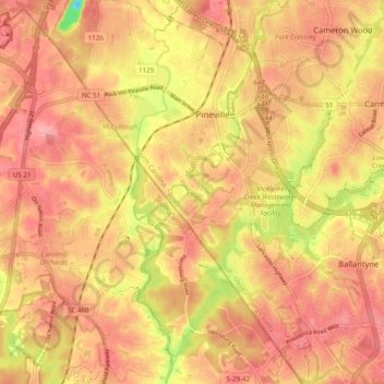
Name: Pineville topographic map, elevation, terrain.
Average elevation: 577 ft
Minimum elevation: 341 ft
Maximum elevation: 676 ft
Mecklenburg County trails, hiking, mountain biking, running and outdoor activities
Make a donation
Gear up for your next adventure:
As an Amazon Associate, this site earns from qualifying purchases at no extra cost to you.
Other topographic maps
Click on a map to view its topography, its elevation and its terrain.
Coulwood Park
United States > North Carolina > Mecklenburg County > Charlotte > Coulwood Hills
Average elevation: 692 ft
Idlewild Farms
United States > North Carolina > Mecklenburg County > Charlotte
Average elevation: 728 ft
Make a donation
Gear up for your next adventure:
As an Amazon Associate, this site earns from qualifying purchases at no extra cost to you.
Make a donation
Gear up for your next adventure:
As an Amazon Associate, this site earns from qualifying purchases at no extra cost to you.
Olde Georgetowne
United States > North Carolina > Mecklenburg County > Charlotte
Average elevation: 636 ft
Mecklenberg Wildlife Club Lake
United States > North Carolina > Mecklenburg County > Charlotte
Average elevation: 702 ft
Mecklenburg County Sportsplex at Matthews
United States > North Carolina > Mecklenburg County > Matthews > Club View Acres
Average elevation: 738 ft
Make a donation
Gear up for your next adventure:
As an Amazon Associate, this site earns from qualifying purchases at no extra cost to you.
Oakdale Forest
United States > North Carolina > Mecklenburg County > Charlotte
Average elevation: 745 ft
Beverly Woods East
United States > North Carolina > Mecklenburg County > Charlotte
Average elevation: 666 ft
Make a donation
Gear up for your next adventure:
As an Amazon Associate, this site earns from qualifying purchases at no extra cost to you.
North Mecklenburg Park
United States > North Carolina > Mecklenburg County > Huntersville
Average elevation: 781 ft
Hope Park
United States > North Carolina > Mecklenburg County > Charlotte > Hope Park
Average elevation: 764 ft
Make a donation
Gear up for your next adventure:
As an Amazon Associate, this site earns from qualifying purchases at no extra cost to you.
Country Roads
United States > North Carolina > Mecklenburg County > Charlotte > Country Roads
Average elevation: 653 ft
Make a donation
Gear up for your next adventure:
As an Amazon Associate, this site earns from qualifying purchases at no extra cost to you.
Carmel Road Park
United States > North Carolina > Mecklenburg County > Charlotte > Carmel Woods
Average elevation: 650 ft
Deschutes Pond
United States > North Carolina > Mecklenburg County > Huntersville
Average elevation: 735 ft
Make a donation
Gear up for your next adventure:
As an Amazon Associate, this site earns from qualifying purchases at no extra cost to you.
President James K. Polk State Historic Site
United States > North Carolina > Mecklenburg County > Pineville
Average elevation: 574 ft