
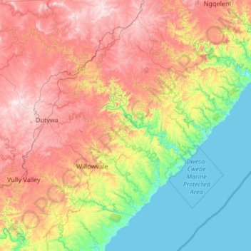
Mbhashe Local Municipality topographic map
Interactive map
Click on the map to display elevation.
About this map
Name: Mbhashe Local Municipality topographic map, elevation, terrain.
Average elevation: 1,394 ft
Minimum elevation: 0 ft
Maximum elevation: 3,658 ft
Other topographic maps
Click on a map to view its topography, its elevation and its terrain.
Komga
South Africa > Eastern Cape > Amathole District Municipality > Great Kei Local Municipality
Komga, Great Kei Local Municipality, Amathole District Municipality, Eastern Cape, South Africa
Average elevation: 1,978 ft
Nqamakwe River
South Africa > Eastern Cape > Amathole District Municipality > Mnquma Local Municipality
Nqamakwe River, Mnquma Local Municipality, Amathole District Municipality, Eastern Cape, South Africa
Average elevation: 2,503 ft
Dutywa
South Africa > Eastern Cape > Amathole District Municipality > Mbhashe Local Municipality
Dutywa, Mbhashe Local Municipality, Amathole District Municipality, Eastern Cape, South Africa
Average elevation: 2,733 ft
Keiskammahoek
South Africa > Eastern Cape > Amathole District Municipality > Amahlathi Local Municipality
Keiskammahoek, Amahlathi Local Municipality, Amathole District Municipality, Eastern Cape, 5670, South Africa
Average elevation: 2,195 ft
Ngqushwa Local Municipality
South Africa > Eastern Cape > Amathole District Municipality
Ngqushwa Local Municipality, Amathole District Municipality, Eastern Cape, South Africa
Average elevation: 761 ft
Mbashe
South Africa > Eastern Cape > Amathole District Municipality > Mbhashe Local Municipality
Mbashe, Mbhashe Ward 21, Mbhashe Local Municipality, Amathole District Municipality, Eastern Cape, South Africa
Average elevation: 217 ft
Amahlathi Local Municipality
South Africa > Eastern Cape > Amathole District Municipality
Amahlathi Local Municipality, Amathole District Municipality, Eastern Cape, 5670, South Africa
Average elevation: 2,776 ft
Peddie
South Africa > Eastern Cape > Amathole District Municipality > Ngqushwa Local Municipality
Peddie, Ngqushwa Local Municipality, Amathole District Municipality, Eastern Cape, South Africa
Average elevation: 1,086 ft
Gcuwa River
South Africa > Eastern Cape > Amathole District Municipality > Mnquma Local Municipality > Butterworth
Gcuwa River, Mnquma Ward 1, Butterworth, Mnquma Local Municipality, Amathole District Municipality, Eastern Cape, 4960, South Africa
Average elevation: 1,854 ft
Bedford
South Africa > Eastern Cape > Amathole District Municipality > Nxuba Local Municipality
Bedford, Nxuba Local Municipality, Amathole District Municipality, Eastern Cape, South Africa
Average elevation: 2,789 ft
Hogsback
South Africa > Eastern Cape > Amathole District Municipality > Nkonkobe Local Municipality
Hogsback, Nkonkobe Local Municipality, Amathole District Municipality, Eastern Cape, 5721, South Africa
Average elevation: 3,993 ft
Cathcart
South Africa > Eastern Cape > Amathole District Municipality > Amahlathi Local Municipality
Cathcart, Amahlathi Local Municipality, Amathole District Municipality, Eastern Cape, South Africa
Average elevation: 3,924 ft
Ngxutyana River
South Africa > Eastern Cape > Amathole District Municipality > Mbhashe Local Municipality
Ngxutyana River, Mbhashe Local Municipality, Amathole District Municipality, Eastern Cape, South Africa
Average elevation: 289 ft
Marshstrand
South Africa > Eastern Cape > Amathole District Municipality > Great Kei Local Municipality
Marshstrand, Great Kei Local Municipality, Amathole District Municipality, Eastern Cape, South Africa
Average elevation: 121 ft
Alice
South Africa > Eastern Cape > Amathole District Municipality > Nkonkobe Local Municipality
Alice, Nkonkobe Local Municipality, Amathole District Municipality, Eastern Cape, South Africa
Average elevation: 1,923 ft
Ntaba kaNdoda Peak
South Africa > Eastern Cape > Amathole District Municipality > Amahlathi Local Municipality
Ntaba kaNdoda Peak, Amahlathi Local Municipality, Amathole District Municipality, Eastern Cape, South Africa
Average elevation: 2,451 ft
Goshen
South Africa > Eastern Cape > Amathole District Municipality > Amahlathi Local Municipality
Goshen, Amahlathi Local Municipality, Amathole District Municipality, Eastern Cape, South Africa
Average elevation: 3,990 ft
Cumakala
South Africa > Eastern Cape > Amathole District Municipality > Amahlathi Local Municipality > Cumakala
Cumakala, Amahlathi Local Municipality, Amathole District Municipality, Eastern Cape, South Africa
Average elevation: 2,743 ft
Kat River
South Africa > Eastern Cape > Amathole District Municipality > Nkonkobe Local Municipality
Kat River, Nkonkobe Local Municipality, Amathole District Municipality, Eastern Cape, South Africa
Average elevation: 1,070 ft
Ngqatyana
South Africa > Eastern Cape > Amathole District Municipality > Mbhashe Local Municipality
Ngqatyana, Mbhashe Local Municipality, Amathole District Municipality, Eastern Cape, South Africa
Average elevation: 879 ft
Kubusi River
South Africa > Eastern Cape > Amathole District Municipality > Amahlathi Local Municipality
Kubusi River, Amahlathi Local Municipality, Amathole District Municipality, Eastern Cape, South Africa
Average elevation: 2,621 ft
Butterworth
South Africa > Eastern Cape > Amathole District Municipality > Mnquma Local Municipality
Butterworth, Mnquma Local Municipality, Amathole District Municipality, Eastern Cape, 4960, South Africa
Average elevation: 1,975 ft
Fort Beaufort
South Africa > Eastern Cape > Amathole District Municipality > Nkonkobe Local Municipality > Fort Beaufort
Fort Beaufort, Nkonkobe Local Municipality, Amathole District Municipality, Eastern Cape, 5720, South Africa
Average elevation: 1,581 ft
Stutterheim
South Africa > Eastern Cape > Amathole District Municipality > Amahlathi Local Municipality
Stutterheim, Amahlathi Local Municipality, Amathole District Municipality, Eastern Cape, South Africa
Average elevation: 2,736 ft
Great Fish River Nature Reserve
South Africa > Eastern Cape > Amathole District Municipality
Great Fish River Nature Reserve, Amathole District Municipality, Eastern Cape, South Africa
Average elevation: 1,161 ft
Mnquma Local Municipality
South Africa > Eastern Cape > Amathole District Municipality
Mnquma Local Municipality, Amathole District Municipality, Eastern Cape, South Africa
Average elevation: 1,821 ft
Great Kei Local Municipality
South Africa > Eastern Cape > Amathole District Municipality
Great Kei Local Municipality, Amathole District Municipality, Eastern Cape, South Africa
Average elevation: 968 ft