Geolocate

Ash topographic map

Click on the map to display elevation.

About this map

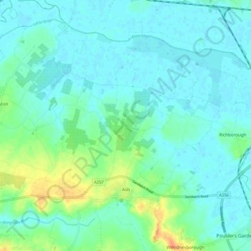
Name: Ash topographic map, elevation, terrain.

Location: Ash, Dover, Kent, England, United Kingdom (51.27145 1.24043 51.32409 1.34596)

Average elevation: 30 ft

Minimum elevation: -3 ft

Maximum elevation: 131 ft

Other topographic maps

Click on a map to view its topography, its elevation and its terrain.

River Stour

United Kingdom > England > Kent > Dover > Ash

Average elevation: 10 ft

Dover Castle

United Kingdom > England > Kent > Dover

Average elevation: 154 ft

Martin

United Kingdom > England > Kent > Dover

Average elevation: 230 ft

Ringwould

United Kingdom > England > Kent > Dover

Average elevation: 148 ft

Waldershare

United Kingdom > England > Kent > Dover > Tilmanstone

Average elevation: 292 ft

Kearsney

United Kingdom > England > Kent > Dover

Average elevation: 308 ft

Elmstone

United Kingdom > England > Kent > Dover > Preston

Average elevation: 43 ft

Sandwich Bay

United Kingdom > England > Kent > Dover

Average elevation: 3 ft

Westmarsh

United Kingdom > England > Kent > Dover > Ash

Average elevation: 26 ft

Ham

United Kingdom > England > Kent > Dover

Average elevation: 52 ft

Shatterling

United Kingdom > England > Kent > Dover > Staple

Average elevation: 59 ft

Church Hougham

United Kingdom > England > Kent > Dover

Average elevation: 292 ft

Wootton

United Kingdom > England > Kent > Dover

Average elevation: 390 ft

Green Lane Hill

United Kingdom > England > Kent > Dover > Whitfield

Average elevation: 305 ft

Hacklinge

United Kingdom > England > Kent > Dover > Worth

Average elevation: 33 ft

Lower Eythorne

United Kingdom > England > Kent > Dover > Eythorne

Average elevation: 246 ft

Wolverton

United Kingdom > England > Kent > Dover > Alkham > Wolverton

Average elevation: 354 ft

South Alkham

United Kingdom > England > Kent > Dover > Alkham > South Alkham

Average elevation: 404 ft

Coldred

United Kingdom > England > Kent > Dover > Shepherdswell > Coldred

Average elevation: 348 ft

Barnsole

United Kingdom > England > Kent > Dover > Staple

Average elevation: 79 ft

Richborough

United Kingdom > England > Kent > Dover

Average elevation: 13 ft

Gear up for your next adventure:

🪶Camp Gear Gift Set - Perfect gift bundle for outdoor fans
🌡️Handheld Weather Meters - Measure wind, temp, and pressure for safe mountain travel
🪶Compact Camp Shovel - Folding shovel for campsite tasks
🧭Outdoor Navigation Book - Learn advanced navigation skills
🔥Camping Stove - Portable stove for camping and backcountry cooking

As an Amazon Associate, this site earns from qualifying purchases at no extra cost to you.