Geolocate

Halfway topographic map

Click on the map to display elevation.

About this map

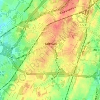
Name: Halfway topographic map, elevation, terrain.

Location: Halfway, Washington County, Maryland, United States (39.60190 -77.80292 39.63345 -77.74120)

Average elevation: 561 ft

Minimum elevation: 466 ft

Maximum elevation: 640 ft

Washington County trails, hiking, mountain biking, running and outdoor activities

Other topographic maps

Click on a map to view its topography, its elevation and its terrain.

Antietam

United States > Maryland > Washington County

Average elevation: 404 ft

Long Meadow

United States > Maryland > Washington County

Average elevation: 630 ft

Cascade

United States > Maryland > Washington County

Average elevation: 1,430 ft

Weverton

United States > Maryland > Washington County

Average elevation: 502 ft

Hillside

United States > Maryland > Washington County > Hillside

Average elevation: 594 ft

Hancock

United States > Maryland > Washington County > Hancock > Hancock

Average elevation: 545 ft

Dargan

United States > Maryland > Washington County

Average elevation: 518 ft

Pleasant Valley

United States > Maryland > Washington County

Average elevation: 1,516 ft

Gear up for your next adventure:

🪶Trail Camera - Capture wildlife on your hikes
🔥Camping Stove - Portable stove for camping and backcountry cooking
🎁Geography Themed Gifts - Unique gift ideas for map lovers and geography enthusiasts
🎒Outdoor Daypacks - Lightweight backpacks designed for carrying maps and essential gear
📷Action Camera - Capture your outdoor adventures in HD

As an Amazon Associate, this site earns from qualifying purchases at no extra cost to you.