Geolocate

Chota topographic map

Click on the map to display elevation.

About this map

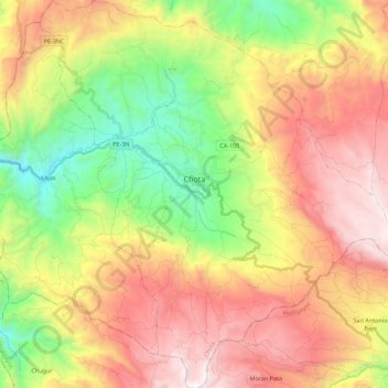
Name: Chota topographic map, elevation, terrain.

Location: Chota, Province of Chota, Cajamarca, Peru (-6.68076 -78.73949 -6.45989 -78.53179)

Average elevation: 9,646 ft

Minimum elevation: 6,890 ft

Maximum elevation: 12,671 ft

Other topographic maps

Click on a map to view its topography, its elevation and its terrain.

Callancas

Peru > Cajamarca > San Pablo

Average elevation: 9,921 ft

Santa Cruz

Peru > Cajamarca

Average elevation: 1,677 ft

El Cardon

Peru > Cajamarca > Cutervo

Average elevation: 7,598 ft

Cruz De Chalpon

Peru > Cajamarca > San Ignacio

Average elevation: 4,882 ft

Regalado

Peru > Cajamarca > Tumbaden

Average elevation: 10,840 ft

Alto Otuzco

Peru > Cajamarca > Los Baños del Inca > Otuzco

Average elevation: 9,275 ft

Yube

Peru > Cajamarca > Callayuc

Average elevation: 5,213 ft

Gear up for your next adventure:

🏔️Mountain Trail Maps - High‑detail maps for popular peaks
🎒Trail Energy Bars - High‑calorie bars for hiking energy
🥤Water Filter Bottle - All‑in‑one filter bottle for safe hydration
🧭Compass with Lanyard - Easy‑carry compass for navigation
🥘Titanium Cookware - Durable, featherlight pots and pans for backpacking

As an Amazon Associate, this site earns from qualifying purchases at no extra cost to you.