
Albany topographic map
Click on the map to display elevation.
Albany
According to the United States Census Bureau, the town has a total area of 75.8 square miles (196.2 km2), of which 75.1 square miles (194.6 km2) are land and 0.58 square miles (1.5 km2) are water, comprising 0.79% of the town. It is drained by the Swift River in the north and the Chocorua River in the south. The town lies fully within the Saco River watershed. Mount Chocorua, the highest point in Albany, has an elevation of 3,474 feet (1,059 m), and Mount Paugus has an elevation of 3,201 ft (976 m).
About this map
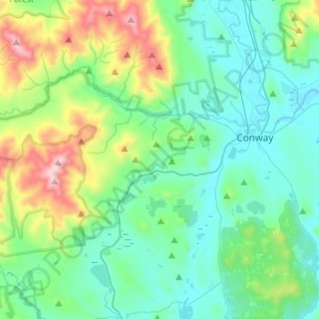
Name: Albany topographic map, elevation, terrain.
Location: Albany, Carroll County, New Hampshire, United States (43.90750 -71.38260 44.02495 -71.14038)
Average elevation: 1,079 ft
Minimum elevation: 410 ft
Maximum elevation: 3,448 ft
Carroll County trails, hiking, mountain biking, running and outdoor activities
Other topographic maps
Click on a map to view its topography, its elevation and its terrain.
Everrett Field
United States > New Hampshire > Carroll County > Sandwich > Center Sandwich
Average elevation: 719 ft
Mirror Lake
United States > New Hampshire > Carroll County > Tuftonboro > Mirror Lake
Average elevation: 554 ft
Mount Willard
United States > New Hampshire > Carroll County > Hart's Location
Average elevation: 2,543 ft
Bill Rae Conservation Area
United States > New Hampshire > Carroll County > Wolfeboro > Stockbridge Corner
Average elevation: 801 ft
Mount Washington Valley
United States > New Hampshire > Carroll County > Conway > North Conway
Average elevation: 820 ft
Sawyers River
United States > New Hampshire > Carroll County > Hart's Location
Average elevation: 1,499 ft
Big Attitash Mountain
United States > New Hampshire > Carroll County > Bartlett
Average elevation: 2,333 ft
Brookfield
United States > New Hampshire > Carroll County > Brookfield
According to the United States Census Bureau, the town has a total area of 23.2 square miles (60.2 km2), of which 22.8 sq mi (59.1 km2) are land and 0.42 sq mi (1.1 km2) are water, comprising 1.82% of the town.[1] Brookfield is drained primarily by the Branch River and Pike Brook, within the Piscataqua River…
Average elevation: 640 ft