Geolocate

Adams topographic map

Click on the map to display elevation.

About this map

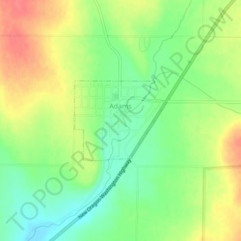
Name: Adams topographic map, elevation, terrain.

Location: Adams, Umatilla County, Oregon, United States (45.76174 -118.57029 45.77069 -118.55549)

Average elevation: 1,558 ft

Minimum elevation: 1,467 ft

Maximum elevation: 1,663 ft

Umatilla County trails, hiking, mountain biking, running and outdoor activities

Other topographic maps

Click on a map to view its topography, its elevation and its terrain.

Tollgate

United States > Oregon > Umatilla County > Tollgate

Average elevation: 4,957 ft

Wallula Gap

United States > Oregon > Umatilla County

Average elevation: 1,027 ft

Ferndale

United States > Oregon > Umatilla County

Average elevation: 840 ft

Ward Butte

United States > Oregon > Umatilla County

Average elevation: 784 ft

Carney Butte

United States > Oregon > Umatilla County

Average elevation: 4,393 ft

Gear up for your next adventure:

🔦Powerful Headlamps - Ultra-bright hands-free lighting for night navigation
🧭Map Reading Tools - Tools and kits for map navigation
🧢Outdoor Hiking Hat - Sun protection hat for outdoor explorers
🧭Pro Hiking Compasses - High-accuracy liquid-filled compasses for topographic orientation
📦Gear Storage Bags - Organize and protect outdoor equipment

As an Amazon Associate, this site earns from qualifying purchases at no extra cost to you.