Geolocate

Ward Butte topographic map

Click on the map to display elevation.

About this map

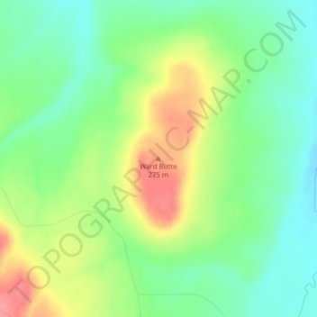
Name: Ward Butte topographic map, elevation, terrain.

Location: Ward Butte, Umatilla County, Oregon, 97826, United States (45.73092 -119.38812 45.73102 -119.38802)

Average elevation: 784 ft

Minimum elevation: 679 ft

Maximum elevation: 945 ft

Umatilla County trails, hiking, mountain biking, running and outdoor activities

Other topographic maps

Click on a map to view its topography, its elevation and its terrain.

Echo

United States > Oregon > Umatilla County

Average elevation: 696 ft

Wallula Gap

United States > Oregon > Umatilla County

Average elevation: 1,027 ft

Mission

United States > Oregon > Umatilla County

Average elevation: 1,407 ft

Stanfield

United States > Oregon > Umatilla County

Average elevation: 633 ft

Adams

United States > Oregon > Umatilla County

Average elevation: 1,558 ft

Gear up for your next adventure:

🧭GPS Watch Accessories - Bands and chargers for GPS watches
🥘Titanium Cookware - Durable, featherlight pots and pans for backpacking
📚Navigation Handbooks - Master the art of reading topographic maps and using a compass
🚑Emergency Bivvies - Heat-reflective sleeping bags for survival situations
📌Outdoor GPS Map App - Apps and devices for digital topographic navigation

As an Amazon Associate, this site earns from qualifying purchases at no extra cost to you.