Geolocate

Wallula Gap topographic map

Click on the map to display elevation.

About this map

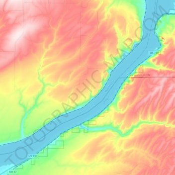
Name: Wallula Gap topographic map, elevation, terrain.

Location: Wallula Gap, Umatilla County, Oregon, 99363, United States (45.92727 -119.16924 46.05525 -118.94420)

Average elevation: 1,027 ft

Minimum elevation: 331 ft

Maximum elevation: 1,765 ft

Umatilla County trails, hiking, mountain biking, running and outdoor activities

Other topographic maps

Click on a map to view its topography, its elevation and its terrain.

Tollgate

United States > Oregon > Umatilla County > Tollgate

Average elevation: 4,957 ft

Echo

United States > Oregon > Umatilla County

Average elevation: 696 ft

Mission

United States > Oregon > Umatilla County

Average elevation: 1,407 ft

Ferndale

United States > Oregon > Umatilla County

Average elevation: 840 ft

Stanfield

United States > Oregon > Umatilla County

Average elevation: 633 ft

Ward Butte

United States > Oregon > Umatilla County

Average elevation: 784 ft

Carney Butte

United States > Oregon > Umatilla County

Average elevation: 4,393 ft

Adams

United States > Oregon > Umatilla County

Average elevation: 1,558 ft

Gear up for your next adventure:

📌Outdoor GPS Map App - Apps and devices for digital topographic navigation
🔥Camping Stove - Portable stove for camping and backcountry cooking
🌄Hiking Binoculars - Compact binoculars for scenic views and trail spotting
🩳Quick‑Dry Hiking Shorts - Comfortable and quick‑dry shorts for summer hiking
🦶Hiking Gaiters - Keep debris and water out of your boots

As an Amazon Associate, this site earns from qualifying purchases at no extra cost to you.