Geolocate

Lluta topographic map

Click on the map to display elevation.

About this map

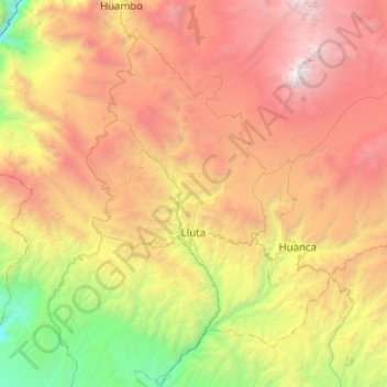
Name: Lluta topographic map, elevation, terrain.

Location: Lluta, Caylloma, Arequipa, Peru (-16.20846 -72.27064 -15.72379 -71.77741)

Average elevation: 11,588 ft

Minimum elevation: 4,334 ft

Maximum elevation: 20,522 ft

Other topographic maps

Click on a map to view its topography, its elevation and its terrain.

Tingo Grande

Peru > Arequipa > Jacobo Hunter

Average elevation: 7,464 ft

Llavepata

Peru > Arequipa

Average elevation: 14,895 ft

Potosi

Peru > Arequipa > Caylloma

Average elevation: 14,560 ft

Mirador Cruz del Condor

Peru > Arequipa > Cabanaconde > Media Luna

Average elevation: 11,657 ft

Nevado Mismi

Peru > Arequipa > Lari

Average elevation: 17,300 ft

Charco

Peru > Arequipa > Yanaquihua

Average elevation: 9,836 ft

Caylloma

Peru > Arequipa

Average elevation: 12,126 ft

Chalhuanca

Peru > Arequipa > Yanque

Average elevation: 14,318 ft

Villa Sevilla

Peru > Arequipa > Jacobo Hunter > Villa Sevilla

Average elevation: 7,490 ft

Catamarca

Peru > Arequipa > Tisco

Average elevation: 13,875 ft

Oroya

Peru > Arequipa > Achoma

Average elevation: 11,545 ft

Gear up for your next adventure:

Solar GPS Watches - Advanced multisport watches with built-in topographic maps
GPS Sports Watch - GPS watch for running, hiking and training
🧭Outdoor Navigation Book - Learn advanced navigation skills
🚁Photography Drones - Capture stunning aerial views of landforms and topography
🗻Climbing Gear Basics - Essential gear for beginner climbers

As an Amazon Associate, this site earns from qualifying purchases at no extra cost to you.